Shared Solution

PID: BBDJ07
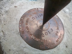
Designation: 872 0219 P TIDAL
Stamping: 0219 P 2013
Stability:
Setting: Object surrounded by mass of concrete
Description: The bench mark is a disk set in the top of a concrete retaining wall along the southwestern edge of the Martin Marietta Aggregates facility pond, located 52.1 m (171.0 ft) NW of the Dames Point Aquatrak sensor, 24.8 m (81.4 ft) W of the eastern edge of the easternmost retaining wall, and 7.5 m (24.1 ft) NE of the interface between rip rap and the western edge of the retaining wall foundation.
Observed: 2013-12-11T12:49:00Z
Source: OPUS - page5 1209.04
Close-up View
REF_FRAME:   NAD_83(2011) EPOCH:   2010.0000 SOURCE:   NAVD88 (Computed using GEOID18) UNITS:  m  SET PROFILE   DETAILS
LAT: 30° 23' 15.61636" ±  0.008   m
LON: -81° 33' 33.54720" ±   0.007   m
ELL HT: -26.442 ±   0.042   m
X: 808291.452 ±   0.007  m
Y: -5446974.575 ±   0.040  m
Z: 3207505.316 ±   0.015  m
ORTHO HT: 1.940 ±  0.068   m
UTM  17 SPC  901(FL E)
NORTHING: 3361876.407m 670973.360m
EASTING: 446265.495m 146247.155m
CONVERGENCE: -0.28293711° -0.28293711°
POINT SCALE: 0.99963562 0.99997681
COMBINED FACTOR: 0.99963977 0.99998096
CONTRIBUTED BY
dweirauch
Woods Hole Group Inc.
Horizon View
The numerical values for this position solution have satisfied the quality control criteria of the National Geodetic Survey. The contributor has verified that the information submitted is accurate and complete.