| PID:
|
BBDJ02 |
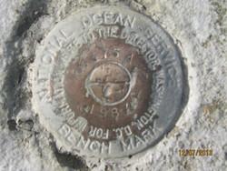
| Designation:
|
846 6375 A |
| Stamping:
|
6375 A 1987 |
| Stability:
|
Monument will probably hold position well |
| Setting:
|
Retaining wall or concrete ledge |
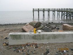
| Description:
|
The primary bench mark is a disk set in the top of the concrete sea wall at the Gulf Beach parking area, near the south end, 73 m (240 ft) SW of the intersection of Gulf Street and Old Field Lane, 1.52 m (5.0 ft) NNW of the south end of the sea wall, 0.15 m (0.5 ft) west of the east face of the sea wall, and 0.61 m (2.0 ft) above the asphalt level of the parking lot. |
| Observed:
|
2013-12-09T15:09:00Z |
| Source:
|
OPUS - page5 1209.04 |
|
|
|
| Close-up View
|
|
| REF_FRAME:
NAD_83(2011) |
EPOCH:
2010.0000 |
SOURCE:
NAVD88 (Computed using GEOID18) |
UNITS:
m |
SET PROFILE
|
DETAILS
|
|
| LAT:
|
41° 12' 29.66423"
|
± 0.008
m |
| LON:
|
-73° 2' 38.63463"
|
±
0.021
m |
| ELL HT:
|
-27.544 |
±
0.008
m |
| X:
|
1401418.513 |
±
0.020
m |
| Y:
|
-4596473.905 |
±
0.005
m |
| Z:
|
4179831.079 |
±
0.012
m |
| ORTHO HT:
|
2.335 |
±
0.058
m |
|
|
UTM
18 |
SPC
600(CT ) |
| NORTHING:
|
4563718.448m |
194078.307m |
| EASTING:
|
663982.565m |
280137.482m |
| CONVERGENCE:
|
1.28885189°
|
-0.19498269°
|
| POINT SCALE:
|
0.99993095 |
0.99999918 |
| COMBINED FACTOR:
|
0.99993527 |
1.00000350 |
|
|
|
|
| Horizon View
|
|
|
|
|