| PID:
|
BBDH98 |
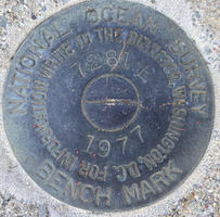
| Designation:
|
844 7281 E TIDAL |
| Stamping:
|
7281 E 1977 |
| Stability:
|
May hold, commonly subject to ground movement |
| Setting:
|
Retaining wall or concrete ledge |
| Mark Condition:
|
G |
| Description:
|
The bench mark is a NOS survey disk set flush in top of a concrete seawall south of the boat shed at 180 River Street, 63.96 m (209.84 ft) SEE of the north corner of the Marina pier. 47.10 m (154.54 ft) W of the centerline of River St. 15.64 m (51.3 ft) NW of the SE end of the seawall, and 5.36 m (17.6 ft) south of the south wall of the boat shed. |
| Observed:
|
2021-06-02T11:22:00Z |
more obs 2021-06-25
|
| Source:
|
OPUS - page5 2008.25 |
|
|
|
| Close-up View
|
|
| REF_FRAME:
NAD_83(2011) |
EPOCH:
2010.0000 |
SOURCE:
NAVD88 (Computed using GEOID18) |
UNITS:
m |
SET PROFILE
|
DETAILS
|
|
| LAT:
|
41° 44' 28.72694"
|
± 0.002
m |
| LON:
|
-71° 7' 52.49482"
|
±
0.000
m |
| ELL HT:
|
-27.375 |
±
0.009
m |
| X:
|
1541381.484 |
±
0.002
m |
| Y:
|
-4510031.839 |
±
0.008
m |
| Z:
|
4224189.828 |
±
0.005
m |
| ORTHO HT:
|
1.993 |
±
0.054
m |
|
|
UTM
19 |
SPC
2001(MA M) |
| NORTHING:
|
4623250.138m |
832403.549m |
| EASTING:
|
322777.279m |
230674.560m |
| CONVERGENCE:
|
-1.41928611°
|
0.24770000°
|
| POINT SCALE:
|
0.99998651 |
0.99999649 |
| COMBINED FACTOR:
|
0.99999080 |
1.00000078 |
|
|
|
|
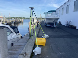
| Horizon View
|
|
|
|
|