| PID:
|
BBDG82 |
| Designation:
|
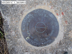
851 2451 C |
| Stamping:
|
2451 C 1989 |
| Stability:
|
May hold, commonly subject to ground movement |
| Setting:
|
Footings of small/medium structures |
| Description:
|
The bench mark is a disk set in a 0.58 m (1.9 ft) by 0.61 m (2.0 ft) concrete footing for an antenna tower that has been removed on the north side of the United States Coast Guard Shinnecock Station grounds, 59.45 m (195.0 ft) NW of the NW corner of the USCG boathouse, 37.02 m (121.5 ft) east of the western most power pole inside the northern fence of the USCG grounds, 19.23 m (63.1 ft) west of the SW corner of a small brick building west of the basketball court and north of the softball field. |
| Observed:
|
2013-09-17T17:44:00Z |
| Source:
|
OPUS - page5 1209.04 |
|
|
|
| Close-up View
|
|
| REF_FRAME:
NAD_83(2011) |
EPOCH:
2010.0000 |
SOURCE:
NAVD88 (Computed using GEOID18) |
UNITS:
m |
SET PROFILE
|
DETAILS
|
|
| LAT:
|
40° 51' 2.60089"
|
± 0.006
m |
| LON:
|
-72° 30' 15.27604"
|
±
0.002
m |
| ELL HT:
|
-29.378 |
±
0.010
m |
| X:
|
1452497.277 |
±
0.003
m |
| Y:
|
-4607922.739 |
±
0.005
m |
| Z:
|
4149878.529 |
±
0.011
m |
| ORTHO HT:
|
2.256 |
±
0.050
m |
|
|
UTM
18 |
SPC
3104(NY L ) |
| NORTHING:
|
4525184.108m |
77038.806m |
| EASTING:
|
710379.534m |
426122.490m |
| CONVERGENCE:
|
1.63304846°
|
0.97834764°
|
| POINT SCALE:
|
1.00014479 |
0.99999490 |
| COMBINED FACTOR:
|
1.00014940 |
0.99999951 |
|
|
|
|
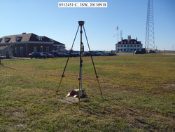
| Horizon View
|
|
|
|
|