| PID:
|
BBDG79 |
| Designation:
|
851 3398 E |
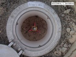
| Stamping:
|
3398 E 2013 |
| Stability:
|
Monument will probably hold position well |
| Setting:
|
Stainless steel rod in sleeve (10FT+ or 3.048M+) |
| Description:
|
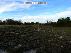
The bench mark is a flange-encased rod set in a clearing on the south side of the sand vehicle track leading to Moriches Inlet, 68.15 m (223.6 ft) WSW of bench mark 851 3398 D, 36.20 m (118.8 ft) SW of "No Daytripping" sign, 29.84 m (97.9 ft) SW of a line of boulders used to prevent vehicle access to clearing, 16.01 m (52.5 ft) SSE of the centerline of the sand vehicle track, and 0.94 m (3.1 ft) NNW of an orange carsonite witness post. |
| Observed:
|
2013-09-15T17:51:00Z |
| Source:
|
OPUS - page5 1209.04 |
|
|
|
| Close-up View
|
|
| REF_FRAME:
NAD_83(2011) |
EPOCH:
2010.0000 |
SOURCE:
NAVD88 (Computed using GEOID18) |
UNITS:
m |
SET PROFILE
|
DETAILS
|
|
| LAT:
|
40° 45' 58.14633"
|
± 0.008
m |
| LON:
|
-72° 45' 24.60949"
|
±
0.002
m |
| ELL HT:
|
-28.104 |
±
0.022
m |
| X:
|
1433988.528 |
±
0.005
m |
| Y:
|
-4620144.125 |
±
0.011
m |
| Z:
|
4142770.907 |
±
0.021
m |
| ORTHO HT:
|
3.616 |
±
0.059
m |
|
|
UTM
18 |
SPC
3104(NY L ) |
| NORTHING:
|
4515218.877m |
67315.224m |
| EASTING:
|
689325.937m |
404958.685m |
| CONVERGENCE:
|
1.46516055°
|
0.81313133°
|
| POINT SCALE:
|
1.00004121 |
0.99999597 |
| COMBINED FACTOR:
|
1.00004562 |
1.00000038 |
|
|
|
|
| Horizon View
|
|
|
|
|