| PID:
|
BBDG16 |
| Designation:
|
945 5963 A |
| Stamping:
|
5963 A 2013 |
| Stability:
|
Monument will probably hold position well |
| Setting:
|
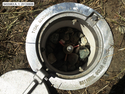
A metal rod driven into ground. Describe below. |
| Description:
|
The bench mark is located at the east end of a small gravel parking area directly south of the Goose Bay Airstrip, 51.41 m (168.7 ft) ESE of the center of the round-about in the gravel parking lot, 13.55 m (44.5 ft) west of the start of a 9 m (30 ft) alder-covered bluff,and 7.43 m (24.4 ft) north of the top of a 6 m (20 ft) high bluff that slopes down to Goose Bay. The datum point is 6 cm (0.2 ft) below grade, the top of a an ss rod driven 4.5 m (15 ft) and encased in a NOS logo cover. |
| Observed:
|
2013-06-05T16:52:00Z |
| Source:
|
OPUS - page5 1209.04 |
|
|
|
| Close-up View
|
|
| REF_FRAME:
NAD_83(2011) |
EPOCH:
2010.0000 |
SOURCE:
NAVD88 (Computed using GEOID12B) |
UNITS:
m |
SET PROFILE
|
DETAILS
|
|
| LAT:
|
61° 23' 31.77863"
|
± 0.008
m |
| LON:
|
-149° 50' 45.50821"
|
±
0.003
m |
| ELL HT:
|
17.788 |
±
0.006
m |
| X:
|
-2647511.420 |
±
0.004
m |
| Y:
|
-1538045.776 |
±
0.003
m |
| Z:
|
5576413.147 |
±
0.009
m |
| ORTHO HT:
|
11.177 |
±
0.012
m |
|
|
UTM
6 |
SPC
5004(AK 4) |
| NORTHING:
|
6809784.261m |
823204.301m |
| EASTING:
|
348008.231m |
508230.163m |
| CONVERGENCE:
|
-2.49900395°
|
0.13522175°
|
| POINT SCALE:
|
0.99988303 |
0.99990083 |
| COMBINED FACTOR:
|
0.99988025 |
0.99989805 |
|
|
|
|
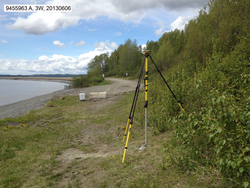
| Horizon View
|
|
|
|
|