| PID:
|
BBDG04 |
| Designation:
|
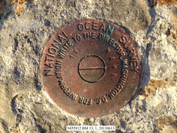
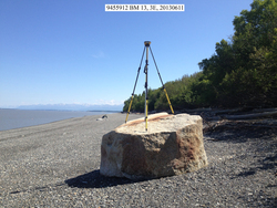
945 5912 BM 13 |
| Stamping:
|
BM 13 1974 |
| Stability:
|
May hold, commonly subject to ground movement |
| Setting:
|
In a boulder |
| Description:
|
The bench mark is a tidal station disk set in the top of a boulder being 2 m high x 3 m wide (7 ft high x 10 ft wide) located on the northern beach of Fire Island, 176.94 m (580.5 ft) ENE of tidal bench mark 945 5912 BM 12, 115 m (377 ft) WSW of tidal bench mark 945 5912 G, 20.22 m (66.3 ft) ESE of a small boulder measuring 0.3 m high x 1 m wide (1 ft high x 3 ft wide), and 12.58 m (41.3 ft) NNW of the vegetation line. |
| Observed:
|
2013-06-13T22:27:00Z |
| Source:
|
OPUS - page5 1209.04 |
|
|
|
| Close-up View
|
|
| REF_FRAME:
NAD_83(2011) |
EPOCH:
2010.0000 |
SOURCE:
NAVD88 (Computed using GEOID12B) |
UNITS:
m |
SET PROFILE
|
DETAILS
|
|
| LAT:
|
61° 10' 22.68557"
|
± 0.010
m |
| LON:
|
-150° 11' 59.44208"
|
±
0.005
m |
| ELL HT:
|
10.718 |
±
0.010
m |
| X:
|
-2675545.716 |
±
0.009
m |
| Y:
|
-1532309.090 |
±
0.006
m |
| Z:
|
5564670.731 |
±
0.008
m |
| ORTHO HT:
|
5.607 |
±
0.018
m |
|
|
UTM
5 |
SPC
5004(AK 4) |
| NORTHING:
|
6785278.384m |
798788.006m |
| EASTING:
|
650592.435m |
489246.824m |
| CONVERGENCE:
|
2.45361393°
|
-0.17508025°
|
| POINT SCALE:
|
0.99987786 |
0.99990142 |
| COMBINED FACTOR:
|
0.99987618 |
0.99989974 |
|
|
|
|
| Horizon View
|
|
|
|
|