| PID:
|
BBDD66 |
| Designation:
|
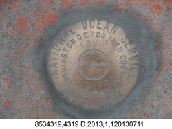
853 4319 D |
| Stamping:
|
4319 D 2013 |
| Stability:
|
Monument will probably hold position well |
| Setting:
|
Massive structures (other than listed below) |
| Description:
|
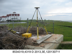
The bench mark is a disk set in top of the NE of three concrete footings formally supporting a USCG communication tower (tower removed) on a peninsula west of the Rutgers University Marine Field Station, 8.50 m (27.9 ft) NE of the center of the westernmost tower footing, 8.49 m (27.8 ft) north of bench mark 853 4319 A, 8.14 m (26.7 ft) north of the center of the SE footing, 0.53 m (1.7 ft) SSW of the center of the northernmost concrete footing, and 0.80 m (2.6 ft) above grade. |
| Observed:
|
2013-07-11T12:22:00Z |
| Source:
|
OPUS - page5 1209.04 |
|
|
|
| Close-up View
|
|
| REF_FRAME:
NAD_83(2011) |
EPOCH:
2010.0000 |
SOURCE:
NAVD88 (Computed using GEOID18) |
UNITS:
m |
SET PROFILE
|
DETAILS
|
|
| LAT:
|
39° 30' 29.91660"
|
± 0.003
m |
| LON:
|
-74° 19' 31.48244"
|
±
0.020
m |
| ELL HT:
|
-32.722 |
±
0.016
m |
| X:
|
1331304.982 |
±
0.023
m |
| Y:
|
-4744344.736 |
±
0.009
m |
| Z:
|
4035994.589 |
±
0.008
m |
| ORTHO HT:
|
1.195 |
±
0.048
m |
|
|
UTM
18 |
SPC
2900(NJ ) |
| NORTHING:
|
4373403.979m |
74942.140m |
| EASTING:
|
557993.780m |
165013.643m |
| CONVERGENCE:
|
0.42917831°
|
0.11107150°
|
| POINT SCALE:
|
0.99964141 |
0.99990277 |
| COMBINED FACTOR:
|
0.99964654 |
0.99990790 |
|
|
|
|
| Horizon View
|
|
|
|
|