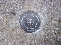
| PID:
|
BBDD60 |
| Designation:
|
857 7004 D |
| Stamping:
|
7004 D 1997 |
| Stability:
|
Most reliable; expected to hold position well |
| Setting:
|
Object surrounded by mass of concrete |
| Mark Condition:
|
G |
| Description:
|
The mark is set in the west corner of the sidewalk leading to the swimming pool and marina office at Flag Harbor Marina, 100 feet SE of a utility pole near the intersection of Flag Harbor Boulevard and Overlook Drive, 46 feet SSW of the NW corner of the marina office building, 28 feet WSW of a concrete sewer cover with a white PVC vent, and 3 feet NE of the NE corner of fence surround swimming pool. |
| Observed:
|
2020-02-24T12:32:00Z |
more obs 2020-02-27
|
| Source:
|
OPUS - page5 1801.18 |
|
|
|
| Close-up View
|
|
| REF_FRAME:
NAD_83(2011) |
EPOCH:
2010.0000 |
SOURCE:
NAVD88 (Computed using GEOID18) |
UNITS:
m |
SET PROFILE
|
DETAILS
|
|
| LAT:
|
38° 27' 46.78690"
|
± 0.005
m |
| LON:
|
-76° 28' 28.48778"
|
±
0.005
m |
| ELL HT:
|
-26.695 |
±
0.011
m |
| X:
|
1169525.096 |
±
0.005
m |
| Y:
|
-4861918.949 |
±
0.008
m |
| Z:
|
3945797.314 |
±
0.006
m |
| ORTHO HT:
|
7.537 |
±
0.054
m |
|
|
UTM
18 |
SPC
1900(MD) |
| NORTHING:
|
4258217.307m |
88527.787m |
| EASTING:
|
371350.762m |
445855.915m |
| CONVERGENCE:
|
-0.91732778°
|
0.32977222°
|
| POINT SCALE:
|
0.99980382 |
0.99997564 |
| COMBINED FACTOR:
|
0.99980801 |
0.99997983 |
|
|
|
|
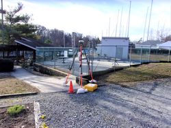
| Horizon View
|
|
|
|
|