| PID:
|
BBDD47 |
| Designation:
|
846 7373 B |
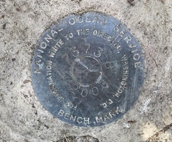
| Stamping:
|
7373 B 2003 |
| Stability:
|
Most reliable; expected to hold position well |
| Setting:
|
Object surrounded by mass of concrete |
| Mark Condition:
|
G |
| Description:
|
In Black Rock, at the Captains Cove Seaport marina, the bench mark is a disk set in the concrete foundation of a sewer access with water meter box located in the center of the marina parking lot, 52.61 m (172.6 ft) NE of the SE corner of the tan house with a plaque stating 1893 Richard Duddon House, 45.86 m (160.5 ft) west of a lamp post in the parking lot, and 0.90 m (3.0 ft) north of the NE corner of the raised foundation of the sewer access. |
| Observed:
|
2022-07-20T11:30:00Z |
more obs 2022-08-25
|
| Source:
|
OPUS - page5 2008.25 |
|
|
|
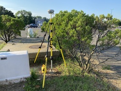
| Close-up View
|
|
| REF_FRAME:
NAD_83(2011) |
EPOCH:
2010.0000 |
SOURCE:
NAVD88 (Computed using GEOID18) |
UNITS:
m |
SET PROFILE
|
DETAILS
|
|
| LAT:
|
41° 9' 31.40993"
|
± 0.009
m |
| LON:
|
-73° 12' 50.57395"
|
±
0.003
m |
| ELL HT:
|
-24.736 |
±
0.025
m |
| X:
|
1388822.032 |
±
0.002
m |
| Y:
|
-4604080.025 |
±
0.019
m |
| Z:
|
4175694.357 |
±
0.022
m |
| ORTHO HT:
|
5.182 |
±
0.063
m |
|
|
UTM
18 |
SPC
600(CT) |
| NORTHING:
|
4557914.568m |
188641.896m |
| EASTING:
|
649843.659m |
265851.645m |
| CONVERGENCE:
|
1.17563889°
|
-0.30769167°
|
| POINT SCALE:
|
0.99987634 |
1.00000443 |
| COMBINED FACTOR:
|
0.99988022 |
1.00000831 |
|
|
|
|
| Horizon View
|
|
|
|
|