| PID:
|
BBDD46 |
| Designation:
|
846 3701 A |
| Stamping:
|
3701 A 2002 |
| Stability:
|
Most reliable; expected to hold position well |
| Setting:
|
Object surrounded by mass of concrete |
| Mark Condition:
|
G |
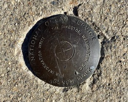
| Description:
|
The bench mark is a disk set in the southerly of two large concrete pads covering fuel tanks at the Aqua Restaurant, just east of the Cedar Island Marina, 19.03 m (62.4 ft) north of the edge of the bulkhead, 14.17 m (46.5 ft) SE of the NE corner of the restaurant, 3.46 m (11.4 ft) west of the SE corner of the pad, and 0.26 m (0.8 ft) north of the south edge of the pad. |
| Observed:
|
2022-07-31T13:42:00Z |
more obs 2022-09-30
|
| Source:
|
OPUS - page5 2008.25 |
|
|
|
| Close-up View
|
|
| REF_FRAME:
NAD_83(2011) |
EPOCH:
2010.0000 |
SOURCE:
NAVD88 (Computed using GEOID18) |
UNITS:
m |
SET PROFILE
|
DETAILS
|
|
| LAT:
|
41° 16' 8.18000"
|
± 0.003
m |
| LON:
|
-72° 31' 51.54154"
|
±
0.006
m |
| ELL HT:
|
-28.301 |
±
0.002
m |
| X:
|
1441188.887 |
±
0.006
m |
| Y:
|
-4579500.830 |
±
0.002
m |
| Z:
|
4184899.686 |
±
0.004
m |
| ORTHO HT:
|
2.015 |
±
0.055
m |
|
|
UTM
18 |
SPC
600(CT) |
| NORTHING:
|
4571552.643m |
200800.696m |
| EASTING:
|
706810.154m |
323152.343m |
| CONVERGENCE:
|
1.62912500°
|
0.14521944°
|
| POINT SCALE:
|
1.00012640 |
0.99999376 |
| COMBINED FACTOR:
|
1.00013084 |
0.99999820 |
|
|
|
|
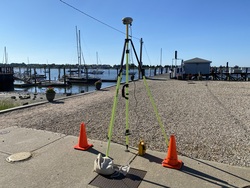
| Horizon View
|
|
|
|
|