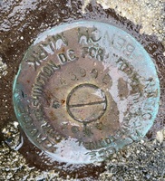
| PID:
|
BBDD16 |
| Designation:
|
855 4399 E |
| Stamping:
|
4399 E 1999 |
| Stability:
|
Most reliable; expected to hold position well |
| Setting:
|
Object surrounded by mass of concrete |
| Mark Condition:
|
G |
| Description:
|
The bench mark is a disk set flush in the concrete and steel bulkhead near the fuel pier, 8.56 m (28.1 ft) NE of the west end of the Delaware Storage and Pipeline Companies fuel pier, 1.71 m (5.6 ft ) south of the north face of the bulkhead, and 1.49 m (4.9 ft) west of the east face of the bulkhead. - Call Del Storage and Pipeline for access: (302) 736-1774 |
| Observed:
|
2021-11-12T14:02:00Z |
more obs 2021-12-07
|
| Source:
|
OPUS - page5 2008.25 |
|
|
|
| Close-up View
|
|
| REF_FRAME:
NAD_83(2011) |
EPOCH:
2010.0000 |
SOURCE:
NAVD88 (Computed using GEOID18) |
UNITS:
m |
SET PROFILE
|
DETAILS
|
|
| LAT:
|
39° 11' 3.37466"
|
± 0.012
m |
| LON:
|
-75° 24' 4.72802"
|
±
0.011
m |
| ELL HT:
|
-32.629 |
±
0.006
m |
| X:
|
1247734.934 |
±
0.008
m |
| Y:
|
-4790578.356 |
±
0.014
m |
| Z:
|
4008173.930 |
±
0.005
m |
| ORTHO HT:
|
1.827 |
±
0.052
m |
|
|
UTM
18 |
SPC
700(DE) |
| NORTHING:
|
4337302.322m |
131462.650m |
| EASTING:
|
465339.833m |
201326.540m |
| CONVERGENCE:
|
-0.25355833°
|
0.00970000°
|
| POINT SCALE:
|
0.99961479 |
0.99999502 |
| COMBINED FACTOR:
|
0.99961991 |
1.00000014 |
|
|
|
|
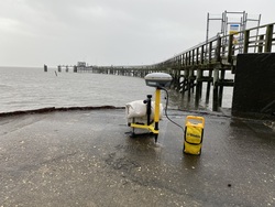
| Horizon View
|
|
|
|
|