| PID:
|
BBDD14 |
| Designation:
|
855 1762 E |
| Stamping:
|
1762 E 2001 |
| Stability:
|
Most reliable; expected to hold position well |
| Setting:
|
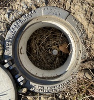
A metal rod driven into ground. Describe below. |
| Mark Condition:
|
G |
| Description:
|
The BM is a flange-encased rod located near the guard shack and the entrance gate and power pole No. PS81, 46.30m (151.9ft) WNW of the NW corner of the guard shack, 37.70 m (123.7ft) NNW of the NE corner of a brick building, 5.40m (17.7ft) WSW of the center line of the road leading onto the property, and 2.10m (6.9ft) SE of power pole No. PS81. The datum point is set 0.3m (1ft) below ground, being the top of a 3-D rod mark driven 17.1m (56ft) to refusal, in a sleeve with an aluminum cover. |
| Observed:
|
2021-11-09T12:15:00Z |
more obs 2021-12-03
|
| Source:
|
OPUS - page5 2008.25 |
|
|
|
| Close-up View
|
|
| REF_FRAME:
NAD_83(2011) |
EPOCH:
2010.0000 |
SOURCE:
NAVD88 (Computed using GEOID18) |
UNITS:
m |
SET PROFILE
|
DETAILS
|
|
| LAT:
|
39° 34' 51.63146"
|
± 0.005
m |
| LON:
|
-75° 35' 19.87231"
|
±
0.009
m |
| ELL HT:
|
-30.849 |
±
0.017
m |
| X:
|
1225092.626 |
±
0.011
m |
| Y:
|
-4767570.025 |
±
0.011
m |
| Z:
|
4042219.856 |
±
0.012
m |
| ORTHO HT:
|
2.479 |
±
0.053
m |
|
|
UTM
18 |
SPC
700(DE) |
| NORTHING:
|
4381420.554m |
175523.442m |
| EASTING:
|
449429.618m |
185206.906m |
| CONVERGENCE:
|
-0.37520556°
|
-0.10971111°
|
| POINT SCALE:
|
0.99963149 |
0.99999769 |
| COMBINED FACTOR:
|
0.99963633 |
1.00000253 |
|
|
|
|
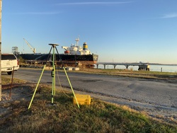
| Horizon View
|
|
|
|
|