| PID:
|
BBDD09 |
| Designation:
|
846 5705 C |
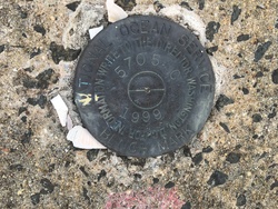
| Stamping:
|
5705 C 1999 |
| Stability:
|
Most reliable; expected to hold position well |
| Setting:
|
Object surrounded by mass of concrete |
| Mark Condition:
|
G |
| Description:
|
The bench mark is a disk set in the NE corner of the fuel pier, 19.38 m (63.6 ft) east of the second bollard on the north side of the shore end of the pier, 3.54 m (11.6 ft) west of the NE outside corner of the pier, 5.55 m (18.2 ft) north of the north railing, and 0.67 m (2.2 ft) south of the first bollard on the north side of pier. |
| Observed:
|
2022-09-11T12:33:00Z |
more obs 2022-10-20
|
| Source:
|
OPUS - page5 2008.25 |
|
|
|
| Close-up View
|
|
| REF_FRAME:
NAD_83(2011) |
EPOCH:
2010.0000 |
SOURCE:
NAVD88 (Computed using GEOID18) |
UNITS:
m |
SET PROFILE
|
DETAILS
|
|
| LAT:
|
41° 16' 59.64496"
|
± 0.002
m |
| LON:
|
-72° 54' 22.00374"
|
±
0.001
m |
| ELL HT:
|
-26.924 |
±
0.009
m |
| X:
|
1410867.629 |
±
0.001
m |
| Y:
|
-4587838.285 |
±
0.008
m |
| Z:
|
4186093.796 |
±
0.005
m |
| ORTHO HT:
|
2.919 |
±
0.056
m |
|
|
UTM
18 |
SPC
600(CT) |
| NORTHING:
|
4572314.070m |
202376.925m |
| EASTING:
|
675348.300m |
291722.575m |
| CONVERGENCE:
|
1.38186111°
|
-0.10351111°
|
| POINT SCALE:
|
0.99997841 |
0.99999264 |
| COMBINED FACTOR:
|
0.99998263 |
0.99999686 |
|
|
|
|
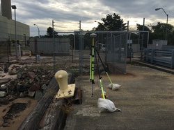
| Horizon View
|
|
|
|
|