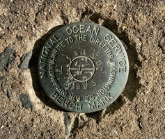
| PID:
|
BBDC92 |
| Designation:
|
846 4445 D |
| Stamping:
|
4445 D 1993 |
| Stability:
|
Most reliable; expected to hold position well |
| Setting:
|
Retaining wall or concrete ledge |
| Mark Condition:
|
G |
| Description:
|
The bench mark is a disk set in the south end of a 0.46 m x 2.29 m (1.5 ft x 7.5 ft) concrete storm drain headwall located just east of the driveway to the small row of townhouses at 373 Whitfield Street, 19.05 m (62.5 ft) SSW of SNET utility pole #7486, 16.25 m (53.3 ft) east of SNET utility pole #b1087, 11.52 m (37.8 ft) NNE of the centerline of Whitfield Street, and 1 m (3 ft) above the ground. |
| Observed:
|
2022-08-01T11:06:00Z |
more obs 2022-09-23
|
| Source:
|
OPUS - page5 2008.25 |
|
|
|
| Close-up View
|
|
| REF_FRAME:
NAD_83(2011) |
EPOCH:
2010.0000 |
SOURCE:
NAVD88 (Computed using GEOID18) |
UNITS:
m |
SET PROFILE
|
DETAILS
|
|
| LAT:
|
41° 16' 25.52156"
|
± 0.006
m |
| LON:
|
-72° 40' 22.50728"
|
±
0.006
m |
| ELL HT:
|
-27.332 |
±
0.021
m |
| X:
|
1429735.109 |
±
0.012
m |
| Y:
|
-4582720.756 |
±
0.017
m |
| Z:
|
4185302.414 |
±
0.009
m |
| ORTHO HT:
|
2.791 |
±
0.061
m |
|
|
UTM
18 |
SPC
600(CT) |
| NORTHING:
|
4571759.045m |
201315.299m |
| EASTING:
|
694906.154m |
311258.909m |
| CONVERGENCE:
|
1.53555833°
|
0.05110833°
|
| POINT SCALE:
|
1.00006754 |
0.99999337 |
| COMBINED FACTOR:
|
1.00007183 |
0.99999766 |
|
|
|
|
| Horizon View
|
|
|
|
|