| PID:
|
BBDC43 |
| Designation:
|
853 5001 A |
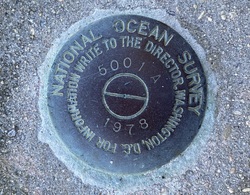
| Stamping:
|
5001 A 1978 |
| Stability:
|
Monument will probably hold position well |
| Setting:
|
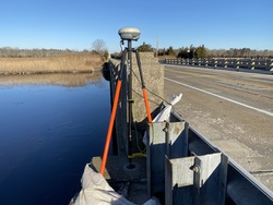
Abutment or pier of large bridges |
| Mark Condition:
|
G |
| Description:
|
The primary bench mark is a disk set flush in the top of the concrete abutment, 51 m (168 ft) south of bench mark 5001 C 1978, 7.07 m (23.2 ft) SW of the centerline of State Highway 50, 0.91 m (3.0 ft) SW of the concrete curb, and 0.34 m (1.1 ft) NE of the SW face of the abutment. |
| Observed:
|
2022-01-27T13:52:00Z |
more obs 2022-02-16
|
| Source:
|
OPUS - page5 2008.25 |
|
|
|
| Close-up View
|
|
| REF_FRAME:
NAD_83(2011) |
EPOCH:
2010.0000 |
SOURCE:
NAVD88 (Computed using GEOID18) |
UNITS:
m |
SET PROFILE
|
DETAILS
|
|
| LAT:
|
39° 14' 49.24738"
|
± 0.005
m |
| LON:
|
-74° 43' 1.00646"
|
±
0.009
m |
| ELL HT:
|
-32.290 |
±
0.031
m |
| X:
|
1303704.680 |
±
0.011
m |
| Y:
|
-4771085.518 |
±
0.021
m |
| Z:
|
4013570.897 |
±
0.021
m |
| ORTHO HT:
|
2.327 |
±
0.060
m |
|
|
UTM
18 |
SPC
2900(NJ) |
| NORTHING:
|
4344226.651m |
45943.019m |
| EASTING:
|
524424.692m |
131274.110m |
| CONVERGENCE:
|
0.17907778°
|
-0.13725556°
|
| POINT SCALE:
|
0.99960735 |
0.99990432 |
| COMBINED FACTOR:
|
0.99961241 |
0.99990939 |
|
|
|
|
| Horizon View
|
|
|
|
|