| PID:
|
BBDC36 |
| Designation:
|
853 8274 C |
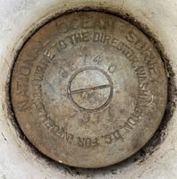
| Stamping:
|
8274 C TIDAL |
| Stability:
|
Monument will probably hold position well |
| Setting:
|
A metal rod driven into ground. Describe below. |
| Mark Condition:
|
G |
| Description:
|
The bench mark is a disk located 37 m (120 ft) SW of bench mark 8274 B 1977, 13.93 m (45.7 ft) SW of wood utility pole #F29790, 8.02 m (26.3 ft) SE of the centerline of County Route 551, 1.62 m (5.3 ft) SE of the SE concrete curb, and 0.67 m (2.2 ft) SE of the steel guard rail. The bench mark is set 6 cm (0.2 ft) below ground level, crimped to the top of a galvanized steel rod driven 15.2 m (50 ft) to refusal, and encased in PVC and concrete kickblock. |
| Observed:
|
2021-11-04T11:30:00Z |
more obs 2021-11-24
|
| Source:
|
OPUS - page5 2008.25 |
|
|
|
| Close-up View
|
|
| REF_FRAME:
NAD_83(2011) |
EPOCH:
2010.0000 |
SOURCE:
NAVD88 (Computed using GEOID18) |
UNITS:
m |
SET PROFILE
|
DETAILS
|
|
| LAT:
|
39° 42' 57.29389"
|
± 0.003
m |
| LON:
|
-75° 21' 41.08482"
|
±
0.011
m |
| ELL HT:
|
-27.820 |
±
0.013
m |
| X:
|
1241593.506 |
±
0.012
m |
| Y:
|
-4753424.575 |
±
0.011
m |
| Z:
|
4053754.672 |
±
0.007
m |
| ORTHO HT:
|
5.351 |
±
0.052
m |
|
|
UTM
18 |
SPC
2900(NJ) |
| NORTHING:
|
4396289.763m |
98329.835m |
| EASTING:
|
469022.441m |
76143.614m |
| CONVERGENCE:
|
-0.23093889°
|
-0.55045278°
|
| POINT SCALE:
|
0.99961181 |
0.99996713 |
| COMBINED FACTOR:
|
0.99961617 |
0.99997149 |
|
|
|
|
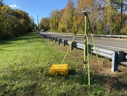
| Horizon View
|
|
|
|
|