| PID:
|
BBDC35 |
| Designation:
|
851 9483 F |
| Stamping:
|
9483 F 1998 |
| Stability:
|
Most reliable; expected to hold position well |
| Setting:
|
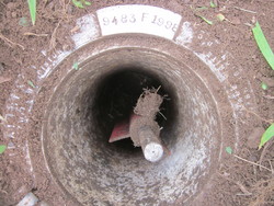
A metal rod driven into ground. Describe below. |
| Description:
|
This station is located in Staten Island at the southwest corner of Faber Park. It is 30.84 ft. west of a north south iron fence, 24.28 ft north of the east west iron fence, 44.5 ft. south of a lamp post, 6.6 ft. NW of a NOAA witness post. The station is a rod mark the datum point is the top of a stainless steel rod encased in a 5 inch NOS logo cap stamped 9483 F 1998 flush with the ground. |
| Observed:
|
2013-07-11T15:46:00Z |
| Source:
|
OPUS - page5 1209.04 |
|
|
|
| Close-up View
|
|
| REF_FRAME:
NAD_83(2011) |
EPOCH:
2010.0000 |
SOURCE:
NAVD88 (Computed using GEOID18) |
UNITS:
m |
SET PROFILE
|
DETAILS
|
|
| LAT:
|
40° 38' 25.46000"
|
± 0.009
m |
| LON:
|
-74° 8' 6.71377"
|
±
0.005
m |
| ELL HT:
|
-24.229 |
±
0.030
m |
| X:
|
1324927.896 |
±
0.013
m |
| Y:
|
-4662063.695 |
±
0.025
m |
| Z:
|
4132187.499 |
±
0.015
m |
| ORTHO HT:
|
7.996 |
±
0.062
m |
|
|
UTM
18 |
SPC
3104(NY L ) |
| NORTHING:
|
4499199.365m |
52615.396m |
| EASTING:
|
573125.419m |
288563.459m |
| CONVERGENCE:
|
0.56327850°
|
-0.08843077°
|
| POINT SCALE:
|
0.99966582 |
1.00000156 |
| COMBINED FACTOR:
|
0.99966962 |
1.00000536 |
|
|
|
|
| Horizon View
|
|
|
|
|