| PID:
|
BBDC32 |
| Designation:
|
853 8438 B |
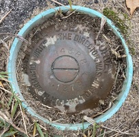
| Stamping:
|
8438 B 1978 |
| Stability:
|
Monument will probably hold position well |
| Setting:
|
A metal rod driven into ground. Describe below. |
| Mark Condition:
|
G |
| Description:
|
The bench mark is a disk located 58 m (190 ft) SW of bench mark 8438 A 1978, 24.84 m (81.5 ft) NW of a wood utility pole, 6.71 m (22.0 ft) west of the centerline of Ferndale Avenue and 1.25 m (4.1 ft) east of the east end of a 1 m (4 ft) high chain link fence. The bench mark is set 4 cm (0.12 ft) below ground level, crimped to the top of a galvanized steel rod driven 15.2 m (50 ft) to refusal, and encased in a PVC pipe and concrete kickblock. |
| Observed:
|
2021-11-02T11:10:00Z |
more obs 2021-11-23
|
| Source:
|
OPUS - page5 2008.25 |
|
|
|
| Close-up View
|
|
| REF_FRAME:
NAD_83(2011) |
EPOCH:
2010.0000 |
SOURCE:
NAVD88 (Computed using GEOID18) |
UNITS:
m |
SET PROFILE
|
DETAILS
|
|
| LAT:
|
39° 47' 44.66749"
|
± 0.001
m |
| LON:
|
-75° 10' 39.46552"
|
±
0.010
m |
| ELL HT:
|
-22.301 |
±
0.006
m |
| X:
|
1255385.339 |
±
0.009
m |
| Y:
|
-4743942.215 |
±
0.006
m |
| Z:
|
4060571.902 |
±
0.004
m |
| ORTHO HT:
|
10.690 |
±
0.050
m |
|
|
UTM
18 |
SPC
2900(NJ) |
| NORTHING:
|
4405101.953m |
107056.901m |
| EASTING:
|
484792.530m |
91968.130m |
| CONVERGENCE:
|
-0.11369167°
|
-0.43373056°
|
| POINT SCALE:
|
0.99960285 |
0.99994145 |
| COMBINED FACTOR:
|
0.99960635 |
0.99994495 |
|
|
|
|
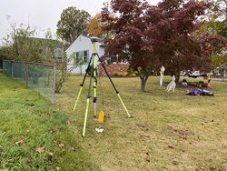
| Horizon View
|
|
|
|
|