| PID:
|
BBDC14 |
| Designation:
|
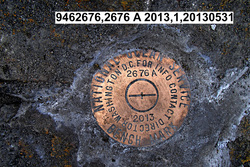
946 2676 A |
| Stamping:
|
2676 A 2013 |
| Stability:
|
Most reliable; expected to hold position well |
| Setting:
|
In rock outcrop or ledge |
| Description:
|
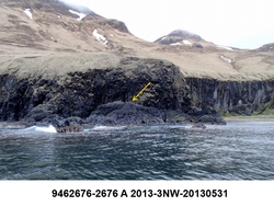
The bench mark is a disk set in the seaward high point of a bedrock outcrop below a rock bluff and south of the stream at the west end of Broad Bight, 31.93 m (104.8 ft) south of the high point of the northern most extent of this rock ledge, 16.66 m (54.7 ft) SSE of the grass above the sandy hollow below the rock bluff, and 14.37 m (47.1 ft) SE of the rock bluff nearest the bench mark. |
| Observed:
|
2013-05-31T01:26:00Z |
| Source:
|
OPUS - page5 1209.04 |
|
|
|
| Close-up View
|
|
| REF_FRAME:
NAD_83(2011) |
EPOCH:
2010.0000 |
SOURCE:
NAVD88 (Computed using GEOID12B) |
UNITS:
m |
SET PROFILE
|
DETAILS
|
|
| LAT:
|
54° 3' 52.12524"
|
± 0.011
m |
| LON:
|
-165° 56' 13.69793"
|
±
0.003
m |
| ELL HT:
|
22.974 |
±
0.010
m |
| X:
|
-3638988.842 |
±
0.013
m |
| Y:
|
-911543.666 |
±
0.001
m |
| Z:
|
5140977.641 |
±
0.007
m |
| ORTHO HT:
|
6.496 |
±
0.019
m |
|
|
UTM
3 |
SPC
5010(AK10) |
| NORTHING:
|
5991101.831m |
387037.062m |
| EASTING:
|
438666.829m |
1656762.697m |
| CONVERGENCE:
|
-0.75880371°
|
8.01931978°
|
| POINT SCALE:
|
0.99964616 |
1.00007914 |
| COMBINED FACTOR:
|
0.99964256 |
1.00007554 |
|
|
|
|
| Horizon View
|
|
|
|
|