| PID:
|
BBDC13 |
| Designation:
|
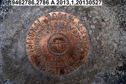
946 2786 A |
| Stamping:
|
2786 A 2013 |
| Stability:
|
Most reliable; expected to hold position well |
| Setting:
|
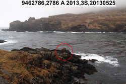
In rock outcrop or ledge |
| Description:
|
The bench mark is a disk set in bedrock on the north side of a small unnamed bay on the east side of Tigalda Island, 22.84 m (74.9 ft) WNW of the west end of the bedrock outcrop at approximately the same elevation, 12.13 m (40.0 ft) SSW of the vegetation line, 11.05 m (36.2 ft) NNE of the top of the black bedrock outcrop with yellow-green lichen, and 1.33 m (4.4 ft) ESE of the west end of the rock point in which the disk is set. |
| Observed:
|
2013-05-27T03:01:00Z |
| Source:
|
OPUS - page5 1209.04 |
|
|
|
| Close-up View
|
|
| REF_FRAME:
NAD_83(2011) |
EPOCH:
2010.0000 |
SOURCE:
NAVD88 (Computed using GEOID12B) |
UNITS:
m |
SET PROFILE
|
DETAILS
|
|
| LAT:
|
54° 6' 6.84890"
|
± 0.002
m |
| LON:
|
-164° 56' 21.74336"
|
±
0.007
m |
| ELL HT:
|
21.000 |
±
0.004
m |
| X:
|
-3619305.272 |
±
0.003
m |
| Y:
|
-973895.777 |
±
0.007
m |
| Z:
|
5143419.546 |
±
0.004
m |
| ORTHO HT:
|
4.274 |
±
0.010
m |
|
|
UTM
3 |
SPC
5010(AK10) |
| NORTHING:
|
5994861.175m |
400716.727m |
| EASTING:
|
503964.350m |
1720753.379m |
| CONVERGENCE:
|
0.04911146°
|
8.81446117°
|
| POINT SCALE:
|
0.99960019 |
1.00009352 |
| COMBINED FACTOR:
|
0.99959690 |
1.00009023 |
|
|
|
|
| Horizon View
|
|
|
|
|