| PID:
|
BBDC11 |
| Designation:
|
854 2425 A |
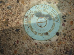
| Stamping:
|
2425 A 1976 |
| Stability:
|
Monument will probably hold position well |
| Setting:
|
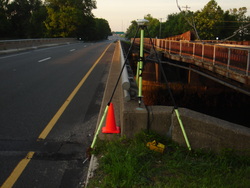
Abutment or pier of large bridges |
| Description:
|
The primary bench mark VM#2907, is a disk set in the NW concrete abutment of the northbound lane of Wannamaker Bridge, 9.02 m (29.6 ft) SE of the corner of the NE abutment, 18.8 FT E of the N end of a steel rail E of the Southbound lane hwy 420, 5.24 m (17.2 ft) west of the centerline of the northbound lane, and 0.55 m (1.8 ft) above grade. |
| Observed:
|
2013-06-22T09:53:00Z |
| Source:
|
OPUS - page5 1209.04 |
|
|
|
| Close-up View
|
|
| REF_FRAME:
NAD_83(2011) |
EPOCH:
2010.0000 |
SOURCE:
NAVD88 (Computed using GEOID18) |
UNITS:
m |
SET PROFILE
|
DETAILS
|
|
| LAT:
|
39° 52' 36.26635"
|
± 0.015
m |
| LON:
|
-75° 18' 17.06181"
|
±
0.001
m |
| ELL HT:
|
-27.883 |
±
0.024
m |
| X:
|
1243395.300 |
±
0.006
m |
| Y:
|
-4741138.724 |
±
0.027
m |
| Z:
|
4067474.225 |
±
0.005
m |
| ORTHO HT:
|
5.093 |
±
0.058
m |
|
|
UTM
18 |
SPC
3702(PA S) |
| NORTHING:
|
4414121.214m |
63233.128m |
| EASTING:
|
473940.804m |
809160.419m |
| CONVERGENCE:
|
-0.19538115°
|
1.58646834°
|
| POINT SCALE:
|
0.99960836 |
1.00000933 |
| COMBINED FACTOR:
|
0.99961273 |
1.00001370 |
|
|
|
|
| Horizon View
|
|
|
|
|