| PID:
|
BBDC03 |
| Designation:
|
853 1142 SEWAREN 1 |
| Stamping:
|
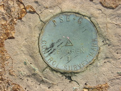
PSE+G SEWAREN 1 CONTROL SURVEY POINT |
| Stability:
|
Most reliable; expected to hold position well |
| Setting:
|
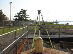
Mat foundation or concrete slab other than pavement |
| Description:
|
The bench mark is a disk set in a 2 m x 2 m (5 ft x 6 ft) concrete foundation of
a mooring bollard on the property of Public Service Electric and Gas (PSEG),
24.87 m (81.6 ft) SSE of the flag pole, 24.23 m (79.5 ft) NE of the NE corner of
the main building at PSEG, and 4.10 m (13.4 ft) WSW of the NW corner of the
bulkhead. |
| Observed:
|
2013-06-25T12:31:00Z |
| Source:
|
OPUS - page5 1209.04 |
|
|
|
| Close-up View
|
|
| REF_FRAME:
NAD_83(2011) |
EPOCH:
2010.0000 |
SOURCE:
NAVD88 (Computed using GEOID18) |
UNITS:
m |
SET PROFILE
|
DETAILS
|
|
| LAT:
|
40° 33' 21.18577"
|
± 0.027
m |
| LON:
|
-74° 14' 43.98536"
|
±
0.022
m |
| ELL HT:
|
-29.737 |
±
0.053
m |
| X:
|
1317603.383 |
±
0.011
m |
| Y:
|
-4670481.134 |
±
0.060
m |
| Z:
|
4125057.463 |
±
0.014
m |
| ORTHO HT:
|
2.739 |
±
0.078
m |
|
|
UTM
18 |
SPC
2900(NJ ) |
| NORTHING:
|
4489731.418m |
191264.799m |
| EASTING:
|
563874.543m |
171548.979m |
| CONVERGENCE:
|
0.49055100°
|
0.16544036°
|
| POINT SCALE:
|
0.99965022 |
0.99990571 |
| COMBINED FACTOR:
|
0.99965488 |
0.99991037 |
|
|
|
|
| Horizon View
|
|
|
|
|