| PID:
|
BBCY46 |
| Designation:
|
945 7292 A |
| Stamping:
|
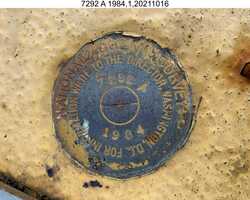
7292 A 1984 |
| Stability:
|
Monument will probably hold position well |
| Setting:
|
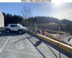
Retaining wall or concrete ledge |
| Mark Condition:
|
G |
| Description:
|
The bench mark is a disk set in the SE corner of the concrete bullrail of the SW most causeway to the cargo pier on the U.S. Coast Guard Base, 23.00 m (75.5 ft) NW from the NW corner of Servmart building #614, 13.00 m (42.7 ft) SE from red fire hydrant #107, and 0.30 m (1.0 ft) NW from SE end of bullrail. |
| Observed:
|
2021-10-16T21:34:00Z |
more obs 2017-07-17
|
| Source:
|
OPUS - page5 2008.25 |
|
|
|
| Close-up View
|
|
| REF_FRAME:
NAD_83(2011) |
EPOCH:
2010.0000 |
SOURCE:
NAVD88 (Computed using GEOID12B) |
UNITS:
m |
SET PROFILE
|
DETAILS
|
|
| LAT:
|
57° 43' 48.82454"
|
± 0.009
m |
| LON:
|
-152° 30' 48.63445"
|
±
0.002
m |
| ELL HT:
|
17.732 |
±
0.008
m |
| X:
|
-3028196.884 |
±
0.008
m |
| Y:
|
-1575472.135 |
±
0.002
m |
| Z:
|
5369770.935 |
±
0.009
m |
| ORTHO HT:
|
6.271 |
±
0.353
m |
|
|
UTM
5 |
SPC
5005(AK 5) |
| NORTHING:
|
6398780.366m |
416250.613m |
| EASTING:
|
528971.859m |
588547.401m |
| CONVERGENCE:
|
0.41135278°
|
1.25697222°
|
| POINT SCALE:
|
0.99961029 |
0.99999610 |
| COMBINED FACTOR:
|
0.99960751 |
0.99999332 |
|
|
|
|
| Horizon View
|
|
|
|
|