| PID:
|
BBCW94 |
| Designation:
|
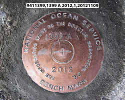
941 1399 A |
| Stamping:
|
1399 A 2012 |
| Stability:
|
Monument will probably hold position well |
| Setting:
|
Mat foundation or concrete slab other than pavement |
| Description:
|
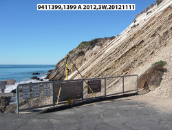
The station is a disk set in a 0.58 m (1.9 ft) thick concrete on top of bedrock access ramp to the Gaviota Pier, 33.89 m (111.2 ft) SW from the north end of the metal railing on the east side of the path near the trestle, 9.95 m (32.6 ft) WNW from the NE corner of the wooden pier, 4.21 m (13.8 ft) NW from the NW corner of the wooden pier, 0.15 m (0.5 ft) NE of the concrete edge, and 0.14 m (0.5 ft) WSW from the metal railing. |
| Observed:
|
2012-11-10T18:43:00Z |
| Source:
|
OPUS - page5 1209.04 |
|
|
|
| Close-up View
|
|
| REF_FRAME:
NAD_83(2011) |
EPOCH:
2010.0000 |
SOURCE:
NAVD88 (Computed using GEOID18) |
UNITS:
m |
SET PROFILE
|
DETAILS
|
|
| LAT:
|
34° 28' 15.21547"
|
± 0.002
m |
| LON:
|
-120° 13' 43.25640"
|
±
0.021
m |
| ELL HT:
|
-29.451 |
±
0.023
m |
| X:
|
-2650097.252 |
±
0.022
m |
| Y:
|
-4548084.435 |
±
0.020
m |
| Z:
|
3589613.825 |
±
0.012
m |
| ORTHO HT:
|
6.537 |
±
0.072
m |
|
|
UTM
10 |
SPC
405(CA 5) |
| NORTHING:
|
3817855.457m |
609965.645m |
| EASTING:
|
754540.295m |
1795277.030m |
| CONVERGENCE:
|
1.56937438°
|
-1.27037544°
|
| POINT SCALE:
|
1.00039869 |
0.99993401 |
| COMBINED FACTOR:
|
1.00040331 |
0.99993863 |
|
|
|
|
| Horizon View
|
|
|
|
|