| PID:
|
BBCV66 |
| Designation:
|
863 3777 C |
| Stamping:
|
3777-C 1988 |
| Stability:
|
Monument will probably hold position well |
| Setting:
|
Stainless steel rod without sleeve (10FT+ or 3.048M+) |
| Mark Condition:
|
G |
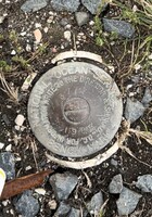
| Description:
|
The station is a disk located in Saxis, VA in the vicinity of a boat ramp and between Harbor Road and the wooden bulkhead. The mark is at ground level, crimped to the top of a stainless steel rod driven 40' to refusal, and encased in a 4-inch PVC pipe. The mark moves slightly along the horizontal plane. It is approximately 65' east of the north corner of the ramp, 25.0' SE of the centerline of Harbor Road, 13.0' NW of the bulkhead, and 3.5' NW of power pole #43050/76916. |
| Observed:
|
2022-10-15T13:13:00Z |
more obs 2021-12-09
|
| Source:
|
OPUS - page5 2008.25 |
|
|
|
| Close-up View
|
|
| REF_FRAME:
NAD_83(2011) |
EPOCH:
2010.0000 |
SOURCE:
NAVD88 (Computed using GEOID18) |
UNITS:
m |
SET PROFILE
|
DETAILS
|
|
| LAT:
|
37° 55' 8.70031"
|
± 0.004
m |
| LON:
|
-75° 43' 38.72244"
|
±
0.005
m |
| ELL HT:
|
-35.370 |
±
0.023
m |
| X:
|
1242026.045 |
±
0.009
m |
| Y:
|
-4882424.485 |
±
0.015
m |
| Z:
|
3898340.895 |
±
0.015
m |
| ORTHO HT:
|
0.928 |
±
0.057
m |
|
|
UTM
18 |
SPC
4502(VA S) |
| NORTHING:
|
4197086.650m |
1179563.806m |
| EASTING:
|
436063.678m |
3743752.526m |
| CONVERGENCE:
|
-0.44705278°
|
1.68274722°
|
| POINT SCALE:
|
0.99965035 |
0.99999166 |
| COMBINED FACTOR:
|
0.99965590 |
0.99999721 |
|
|
|
|
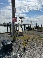
| Horizon View
|
|
|
|
|