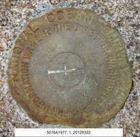
Shared Solution

PID: BBCT90
Designation: 944 5016 A TIDAL
Stamping: 5016 A 1977
Stability: Most reliable; expected to hold position well
Setting: Set in top of concrete monument
Description: To reach the tidal bench marks from the Hansville Community Church, proceed west on Twin Spits Road for 3.4 miles (5.5 km) to a cul de sac. The bench mark is located at private residence.
Disk set flush in marine railway foundation 8.5 m (27.8 ft) shoreward of wooden retaining wall. Set in concrete block that is raised above main concrete platform. 238 deg true, 11.7m (38.4 ft) distant from SE corner of brown steel utility building. 009 deg true, 13m (42.6ft) from concrete fire pit.
Observed: 2012-03-23T00:28:00Z
Source: OPUS - page5 1209.04
Close-up View
REF_FRAME:   NAD_83(2011) EPOCH:   2010.0000 SOURCE:   NAVD88 (Computed using GEOID18) UNITS:  m  SET PROFILE   DETAILS
LAT: 47° 55' 34.99973" ±  0.003   m
LON: -122° 36' 58.60369" ±   0.001   m
ELL HT: -18.487 ±   0.004   m
X: -2307925.115 ±   0.002  m
Y: -3606543.941 ±   0.004  m
Z: 4711382.002 ±   0.003  m
ORTHO HT: 3.777 ±  0.051   m
UTM  10 SPC  4601(WA N)
NORTHING: 5308189.949m 104540.959m
EASTING: 528664.550m 366776.769m
CONVERGENCE: 0.28483224° -1.32743914°
POINT SCALE: 0.99961010 0.99994782
COMBINED FACTOR: 0.99961300 0.99995072
CONTRIBUTED BY
david.francksen
National Oceanic and Atmospheric Administration
Horizon View
The numerical values for this position solution have satisfied the quality control criteria of the National Geodetic Survey. The contributor has verified that the information submitted is accurate and complete.