| PID:
|
BBCT76 |
| Designation:
|
946 5056 A |
| Stamping:
|
5056 A 2012 |
| Stability:
|
Monument will probably hold position well |
| Setting:
|
Stainless steel rod in sleeve (10FT+ or 3.048M+) |
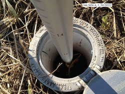
| Description:
|
The bench mark is a stainless steel rod set on the third ridge inland from shore, 67.22 m (220.5 ft) WNW of bench mark 946 5056 TIDAL 4, 57.79 m (189.6 ft) ESE of bench mark 946 5056 TIDAL 3 1949, and 27.28 m (89.5 ft) SSE of the highest point of nearest prominent ridge. The datum point is set 7 cm (0.2 ft) below grade, being the top of a stainless steel rod driven 15.0 m (49 ft) to refusal, and encased in a 5-inch NOS logo cover. |
| Observed:
|
2012-05-22T22:12:00Z |
more obs Original
|
| Source:
|
OPUS - page5 1209.04 |
|
|
|
| Close-up View
|
|
| REF_FRAME:
NAD_83(2011) |
EPOCH:
2010.0000 |
SOURCE:
NAVD88 (Computed using GEOID12B) |
UNITS:
m |
SET PROFILE
|
DETAILS
|
|
| LAT:
|
58° 29' 46.64250"
|
± 0.003
m |
| LON:
|
-158° 42' 48.58478"
|
±
0.002
m |
| ELL HT:
|
18.032 |
±
0.005
m |
| X:
|
-3113129.895 |
±
0.004
m |
| Y:
|
-1212913.954 |
±
0.003
m |
| Z:
|
5414842.438 |
±
0.004
m |
| ORTHO HT:
|
4.553 |
±
0.011
m |
|
|
UTM
4 |
SPC
5006(AK 6) |
| NORTHING:
|
6484001.379m |
500815.162m |
| EASTING:
|
516700.058m |
458398.940m |
| CONVERGENCE:
|
0.24427588°
|
-0.60833964°
|
| POINT SCALE:
|
0.99960342 |
0.99992121 |
| COMBINED FACTOR:
|
0.99960060 |
0.99991839 |
|
|
|
|
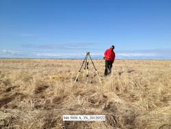
| Horizon View
|
|
|
|
|