| PID:
|
BBCT67 |
| Designation:
|
946 2723 B |
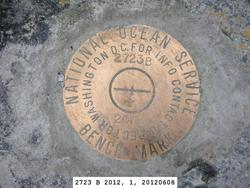
| Stamping:
|
2723 B 2012 |
| Stability:
|
Most reliable; expected to hold position well |
| Setting:
|
In rock outcrop or ledge |
| Description:
|
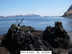
The bench mark is near the center of the second large rock outcrop north of a sandy beach and a creek which is located in an unnamed bay on the NE side of Rootok Island, 101.9 m (334 ft) SE of bench mark 946 2723 C, 89.35 m (293.1 ft) NNE of bench mark 946 2723 A, 7.05 m (23.1 ft) ENE of the high point of the western extent of the rock outcrop, 3.39 m (11.1 ft) WSW of the highest point of the rock outcrop, 1.70 m (5.6 ft) SE of the NW rock outcrop cliff edge, and 4.5 m (15 ft) above the beach. |
| Observed:
|
2012-06-07T22:03:00Z |
| Source:
|
OPUS - page5 1209.04 |
|
|
|
| Close-up View
|
|
| REF_FRAME:
NAD_83(2011) |
EPOCH:
2010.0000 |
SOURCE:
NAVD88 (Computed using GEOID12B) |
UNITS:
m |
SET PROFILE
|
DETAILS
|
|
| LAT:
|
54° 3' 7.92195"
|
± 0.001
m |
| LON:
|
-165° 30' 50.33349"
|
±
0.004
m |
| ELL HT:
|
20.931 |
±
0.003
m |
| X:
|
-3633227.633 |
±
0.003
m |
| Y:
|
-938670.722 |
±
0.004
m |
| Z:
|
5140173.788 |
±
0.002
m |
| ORTHO HT:
|
4.271 |
±
0.008
m |
|
|
UTM
3 |
SPC
5010(AK10) |
| NORTHING:
|
5989451.729m |
389630.973m |
| EASTING:
|
466351.050m |
1684386.975m |
| CONVERGENCE:
|
-0.41609873°
|
8.35654290°
|
| POINT SCALE:
|
0.99961389 |
1.00007451 |
| COMBINED FACTOR:
|
0.99961061 |
1.00007123 |
|
|
|
|
| Horizon View
|
|
|
|
|