| PID:
|
BBCS93 |
| Designation:
|
865 4572 A |
| Stamping:
|
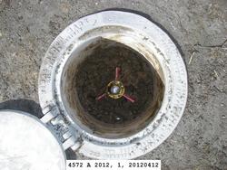
4572 A 2012 |
| Stability:
|
Monument will probably hold position well |
| Setting:
|
Stainless steel rod in sleeve (10FT+ or 3.048M+) |
| Description:
|
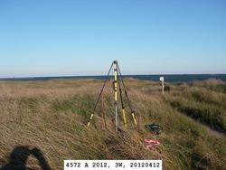
The bench mark is 66.85 m (219.3 ft) west of bench mark NC 12 8, 18.05 m (59.2 ft) south of Pamlico Sound, 13.31 m (43.7 ft) SE of a 4x4 wooden post with white sign, 3.59 m (11.8 ft) south of the centerline of a 2 track sand path and 0.38 m (1.2 ft) north of an NOS witness post. The datum point is set 8 cm (3 inches) below ground, being the top of a stainless steel rod driven 26.8 m (88 ft) to refusal, in a sleeve extending to a depth of 0.9 m (3.0 ft) and encased in a 5-inch NOS logo cap. |
| Observed:
|
2012-04-11T21:08:00Z |
| Source:
|
OPUS - page5 1209.04 |
|
|
|
| Close-up View
|
|
| REF_FRAME:
NAD_83(2011) |
EPOCH:
2010.0000 |
SOURCE:
NAVD88 (Computed using GEOID18) |
UNITS:
m |
SET PROFILE
|
DETAILS
|
|
| LAT:
|
35° 10' 15.58983"
|
± 0.006
m |
| LON:
|
-75° 49' 1.36963"
|
±
0.001
m |
| ELL HT:
|
-38.192 |
±
0.016
m |
| X:
|
1278874.200 |
±
0.004
m |
| Y:
|
-5060392.244 |
±
0.016
m |
| Z:
|
3653368.613 |
±
0.004
m |
| ORTHO HT:
|
0.401 |
±
0.049
m |
|
|
UTM
18 |
SPC
3200(NC ) |
| NORTHING:
|
3892311.856m |
162278.688m |
| EASTING:
|
425597.679m |
899475.061m |
| CONVERGENCE:
|
-0.47065595°
|
1.83710573°
|
| POINT SCALE:
|
0.99966822 |
0.99987358 |
| COMBINED FACTOR:
|
0.99967421 |
0.99987957 |
|
|
|
|
| Horizon View
|
|
|
|
|