| PID:
|
BBCS62 |
| Designation:
|
865 5353 B |
| Stamping:
|
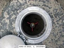
5353 B 2012 |
| Stability:
|
Monument will probably hold position well |
| Setting:
|
Stainless steel rod in sleeve (10FT+ or 3.048M+) |
| Description:
|
The bench mark is a flange-encased rod located in juniper bushes north of a sand parking area, 21.62 m (70.9 ft) ENE of the east bank of a slough, 8.02 m (26.3 ft) north of the center of the parking area, 1.13 m (3.7 ft) SSW of an orange carsonite NOS witness post, and 1.12 m (3.7 ft) south of a wooden 4x4 post with a sign stamped "P" for parking. The datum point is set 10 cm (4.0 in) below grade and encased in a 5-inch NGS logo cap with concrete kickblock. |
| Observed:
|
2012-03-31T22:41:00Z |
| Source:
|
OPUS - page5 1209.04 |
|
|
|
| Close-up View
|
|
| REF_FRAME:
NAD_83(2011) |
EPOCH:
2010.0000 |
SOURCE:
NAVD88 (Computed using GEOID18) |
UNITS:
m |
SET PROFILE
|
DETAILS
|
|
| LAT:
|
34° 58' 42.57413"
|
± 0.004
m |
| LON:
|
-76° 9' 40.80272"
|
±
0.009
m |
| ELL HT:
|
-37.637 |
±
0.014
m |
| X:
|
1251379.247 |
±
0.008
m |
| Y:
|
-5079902.223 |
±
0.012
m |
| Z:
|
3635890.567 |
±
0.010
m |
| ORTHO HT:
|
0.359 |
±
0.051
m |
|
|
UTM
18 |
SPC
3200(NC ) |
| NORTHING:
|
3871273.917m |
139982.239m |
| EASTING:
|
393996.113m |
868740.208m |
| CONVERGENCE:
|
-0.66581878°
|
1.63839353°
|
| POINT SCALE:
|
0.99973849 |
0.99988390 |
| COMBINED FACTOR:
|
0.99974440 |
0.99988981 |
|
|
|
|
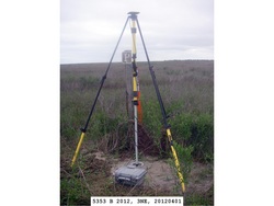
| Horizon View
|
|
|
|
|