| PID:
|
BBCS58 |
| Designation:
|
865 4875 A |
| Stamping:
|
4875 A 2012 |
| Stability:
|
Monument will probably hold position well |
| Setting:
|
Stainless steel rod in sleeve (10FT+ or 3.048M+) |
| Description:
|
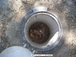
The bench mark is a flange-encased rod set in a garden bed near the intersection of Ballast Point Road and East Harborside Road, 20.93 m (68.7 ft) SW of a fire hydrant, 14.76 m (48.4 ft) west of the corner of a green utility box, 11.70 m (38.4 ft) SSW of the centerline of East Harborside Road, and 10.30 m (33.8 ft) NNE of the seaward edge of the seawall. The datum point is set 18 cm (0.6 ft) below grade and encased in a 5-inch NGS logo cap with concrete kickblock. |
| Observed:
|
2012-04-03T20:35:00Z |
| Source:
|
OPUS - page5 1209.04 |
|
|
|
| Close-up View
|
|
| REF_FRAME:
NAD_83(2011) |
EPOCH:
2010.0000 |
SOURCE:
NAVD88 (Computed using GEOID18) |
UNITS:
m |
SET PROFILE
|
DETAILS
|
|
| LAT:
|
35° 5' 8.53053"
|
± 0.005
m |
| LON:
|
-76° 36' 3.62539"
|
±
0.015
m |
| ELL HT:
|
-36.093 |
±
0.011
m |
| X:
|
1210779.073 |
±
0.015
m |
| Y:
|
-5082714.854 |
±
0.010
m |
| Z:
|
3645630.578 |
±
0.008
m |
| ORTHO HT:
|
1.351 |
±
0.045
m |
|
|
UTM
18 |
SPC
3200(NC ) |
| NORTHING:
|
3883719.522m |
150812.478m |
| EASTING:
|
354051.449m |
828324.059m |
| CONVERGENCE:
|
-0.92042317°
|
1.38462737°
|
| POINT SCALE:
|
0.99986252 |
0.99987677 |
| COMBINED FACTOR:
|
0.99986818 |
0.99988243 |
|
|
|

|
| Horizon View
|
|
|
|
|