| PID:
|
BBCR97 |
| Designation:
|
941 3616 A TIDAL |
| Stamping:
|
3616 A 1976 |
| Stability:
|
Monument will probably hold position well |
| Setting:
|
Massive structures (other than listed below) |
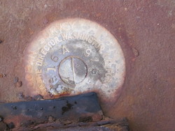
| Description:
|
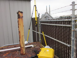
Located in the northeast corner of a concrete block structure, 10.18 m west of the centerline of Moss Landing road, 1.89 m south of the southeast corner of shop building. Disk is partially covered with a steel plate, but center of disk is available. |
| Observed:
|
2012-04-10T16:32:00Z |
| Source:
|
OPUS - page5 1209.04 |
|
|
|
| Close-up View
|
|
| REF_FRAME:
NAD_83(2011) |
EPOCH:
2010.0000 |
SOURCE:
NAVD88 (Computed using GEOID18) |
UNITS:
m |
SET PROFILE
|
DETAILS
|
|
| LAT:
|
36° 48' 2.48689"
|
± 0.002
m |
| LON:
|
-121° 47' 17.99506"
|
±
0.004
m |
| ELL HT:
|
-29.608 |
±
0.032
m |
| X:
|
-2693571.627 |
±
0.014
m |
| Y:
|
-4346262.352 |
±
0.021
m |
| Z:
|
3799687.694 |
±
0.019
m |
| ORTHO HT:
|
4.320 |
±
0.064
m |
|
|
UTM
10 |
SPC
404(CA 4) |
| NORTHING:
|
4073447.448m |
666432.688m |
| EASTING:
|
608092.491m |
1751208.150m |
| CONVERGENCE:
|
0.72589973°
|
-1.66348302°
|
| POINT SCALE:
|
0.99974394 |
0.99994540 |
| COMBINED FACTOR:
|
0.99974859 |
0.99995005 |
|
|
|
|
| Horizon View
|
|
|
|
|