| PID:
|
BBCR84 |
| Designation:
|
941 0962 C |
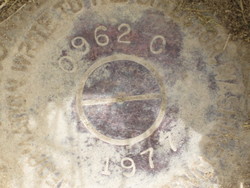
| Stamping:
|
0962 C 1977 |
| Stability:
|
Monument will probably hold position well |
| Setting:
|
Galvanized steel rod without sleeve (10FT+ or 3.048M+) |
| Description:
|
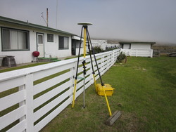
Located near the ranch foremans house, 112 m NW of a gate to the gravel ramp leading to the pier, 24 m SSW of the west end of the gate located just east of the NE corner of ranch foreman house, 6.8 m east of the SE corner of the house and in line with the front of the house, 5.15 m N of the SE yard fence corner, and 0.58 m east of a wooden yard fence. |
| Observed:
|
2012-03-29T17:59:00Z |
| Source:
|
OPUS - page5 1209.04 |
|
|
|
| Close-up View
|
|
| REF_FRAME:
NAD_83(2011) |
EPOCH:
2010.0000 |
SOURCE:
NAVD88 (Computed using GEOID18) |
UNITS:
m |
SET PROFILE
|
DETAILS
|
|
| LAT:
|
34° 0' 29.76001"
|
± 0.003
m |
| LON:
|
-120° 2' 58.53371"
|
±
0.001
m |
| ELL HT:
|
-20.573 |
±
0.012
m |
| X:
|
-2650330.637 |
±
0.005
m |
| Y:
|
-4581345.017 |
±
0.008
m |
| Z:
|
3547195.214 |
±
0.008
m |
| ORTHO HT:
|
15.534 |
±
0.075
m |
|
|
UTM
11 |
SPC
405(CA 5) |
| NORTHING:
|
3767267.198m |
558310.397m |
| EASTING:
|
218353.842m |
1810679.235m |
| CONVERGENCE:
|
-1.70679826°
|
-1.16829222°
|
| POINT SCALE:
|
1.00057798 |
1.00000553 |
| COMBINED FACTOR:
|
1.00058121 |
1.00000876 |
|
|
|
|
| Horizon View
|
|
|
|
|