| PID:
|
BBCR83 |
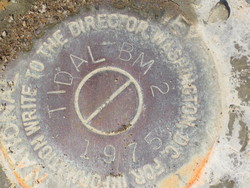
| Designation:
|
941 0738 TIDAL 2 |
| Stamping:
|
TIDAL BM 2 1975 |
| Stability:
|
Monument will probably hold position well |
| Setting:
|
Pavement (street, sidewalk, curb, etc.) |
| Description:
|
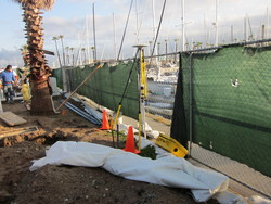
Set in the west edge of the concrete sidewalk running North-South along the seawall of the harbor at basin 2, 13.1 m SE of a wooden sign, 3,81 m SE from a palm tree, 1.37 m WSW from the eastern edge of sidewalk with metal railing. NOTE--this area is under construction and may change drastically. |
| Observed:
|
2012-03-26T14:52:00Z |
| Source:
|
OPUS - page5 1209.04 |
|
|
|
| Close-up View
|
|
| REF_FRAME:
NAD_83(2011) |
EPOCH:
2010.0000 |
SOURCE:
NAVD88 (Computed using GEOID18) |
UNITS:
m |
SET PROFILE
|
DETAILS
|
|
| LAT:
|
33° 50' 50.75362"
|
± 0.007
m |
| LON:
|
-118° 23' 55.12745"
|
±
0.006
m |
| ELL HT:
|
-33.962 |
±
0.018
m |
| X:
|
-2521970.264 |
±
0.010
m |
| Y:
|
-4664549.796 |
±
0.011
m |
| Z:
|
3532385.224 |
±
0.014
m |
| ORTHO HT:
|
2.115 |
±
0.053
m |
|
|
UTM
11 |
SPC
405(CA 5) |
| NORTHING:
|
3746119.483m |
538612.869m |
| EASTING:
|
370602.650m |
1963103.834m |
| CONVERGENCE:
|
-0.77913105°
|
-0.22723326°
|
| POINT SCALE:
|
0.99980641 |
1.00004548 |
| COMBINED FACTOR:
|
0.99981174 |
1.00005081 |
|
|
|
|
| Horizon View
|
|
|
|
|