| PID:
|
BBCQ20 |
| Designation:
|
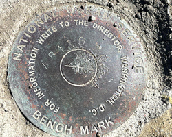
941 4811 G |
| Stamping:
|
4811 G 2004 |
| Stability:
|
Monument will probably hold position well |
| Setting:
|
Unspecified rock or boulder |
| Mark Condition:
|
G |
| Description:
|
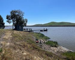
The bench mark is a disk set in a sandstone outcrop located on Bradmoor Island along the slough west of the pier, SE of the SE corner of a 1.9 m square wood frame bldg with water tank on top, 18.6 m (61ft) NW of NW corner of storage building on pier, 4.6 m (15 ft) SW of top of bank and 0.3 m (1 ft) SE of foot high white post. |
| Observed:
|
2022-03-29T19:20:00Z |
more obs 2012-02-06
|
| Source:
|
OPUS - page5 2008.25 |
|
|

|
| Close-up View
|
|
| REF_FRAME:
NAD_83(2011) |
EPOCH:
2010.0000 |
SOURCE:
NAVD88 (Computed using GEOID18) |
UNITS:
m |
SET PROFILE
|
DETAILS
|
|
| LAT:
|
38° 10' 59.24248"
|
± 0.013
m |
| LON:
|
-121° 55' 29.47314"
|
±
0.013
m |
| ELL HT:
|
-29.972 |
±
0.012
m |
| X:
|
-2654538.053 |
±
0.006
m |
| Y:
|
-4260573.079 |
±
0.017
m |
| Z:
|
3921422.770 |
±
0.012
m |
| ORTHO HT:
|
2.178 |
±
0.053
m |
|
|
UTM
10 |
SPC
402(CA 2) |
| NORTHING:
|
4226679.375m |
557333.745m |
| EASTING:
|
594161.082m |
2006584.088m |
| CONVERGENCE:
|
0.66468056°
|
0.04737778°
|
| POINT SCALE:
|
0.99970919 |
1.00003744 |
| COMBINED FACTOR:
|
0.99971389 |
1.00004214 |
|
|
|

|
| Horizon View
|
|
|
|
|