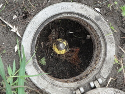
| PID:
|
BBCN89 |
| Designation:
|
876 2482 G |
| Stamping:
|
2482 G 2006 |
| Stability:
|
Most reliable; expected to hold position well |
| Setting:
|
Stainless steel rod in sleeve (10FT+ or 3.048M+) |
| Mark Condition:
|
G |
| Description:
|
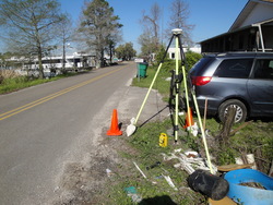
The Bench Mark is located along LA HWY 306, 56 feet ESE of the mailbox at 3683 HWY 306, 74 feet WNW of the mailbox at 3701, 31 feet SSE of the SE corner of the house at 3683, 15 feet NE of the center of LA 306, and 2 feet WSW of a witness post. The datum point is the top of a Stainless Steel rod driven 90 feet to refusal, in a 0.1 m sleeve and encased in a 5-inch PVC pipe with aluminum cover and concrete kickblock. |
| Observed:
|
2018-03-16T13:47:00Z |
more obs 2018-03-23
|
| Source:
|
OPUS - page5 1603.24 |
|
|

|
| Close-up View
|
|
| REF_FRAME:
NAD_83(2011) |
EPOCH:
2010.0000 |
SOURCE:
NAVD88 (Computed using GEOID18) |
UNITS:
m |
SET PROFILE
|
DETAILS
|
|
| LAT:
|
29° 47' 17.13253"
|
± 0.004
m |
| LON:
|
-90° 25' 5.14823"
|
±
0.005
m |
| ELL HT:
|
-25.088 |
±
0.036
m |
| X:
|
-40425.511 |
±
0.004
m |
| Y:
|
-5539794.774 |
±
0.031
m |
| Z:
|
3149996.575 |
±
0.018
m |
| ORTHO HT:
|
0.481 |
±
0.083
m |
|
|
UTM
15 |
SPC
1702(LA S) |
| NORTHING:
|
3298099.605m |
143131.387m |
| EASTING:
|
749589.039m |
1088487.883m |
| CONVERGENCE:
|
1.28333730°
|
0.45762992°
|
| POINT SCALE:
|
1.00036867 |
0.99993260 |
| COMBINED FACTOR:
|
1.00037261 |
0.99993654 |
|
|
|

|
| Horizon View
|
|
|
|
|