| PID:
|
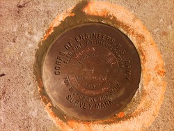
BBCN82 |
| Designation:
|
941 7426 A F AND G |
| Stamping:
|
941 7426A F&G - SEA SURVEYOR 2010 |
| Stability:
|
May hold, commonly subject to ground movement |
| Setting:
|
Retaining wall or concrete ledge |
| Description:
|
Mark is a 4" disk located in the CA Dept. of Fish and Game southern parking lot in Fort Bragg, 58.61 m (192.28 ft) W of the centerline of N Harbor Drive, 23.56 m (77.29 ft) WSW of the SE corner of the California Department of Fish and Game building, 15.42 m (50.58 ft) SE of the SW corner of the California Department of Fish and Game building, and 31.51 m (103.37 ft) E of the SW corner of pier. The mark is set on top of a concrete wall 1.22 m (4 ft) above the ground. Permission is required. |
| Observed:
|
2011-07-27T18:26:00Z |
more obs Original
|
| Source:
|
OPUS - page5 1209.04 |
|
|
|
| Close-up View
|
|