| PID:
|
BBCN78 |
| Designation:
|
946 8258 A |
| Stamping:
|
8258 A 2011 |
| Stability:
|
Monument will probably hold position well |
| Setting:
|
Stainless steel rod in sleeve (10FT+ or 3.048M+) |
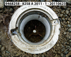
| Description:
|
The station is set in the open tundra between the Bering Sea and Rodney Kinney Road, 46.65 m (153.1 ft) west of the road, 36.52 m (119.8 ft) east of Bench Mark 8258 B 2011, and 20.50 m (67.2 ft) east of the tundra and rocky beach interface. The datum point is set below grade, being the top of a stainless steel rod driven 1.73 m (5.7 ft) to refusal, in a sleeve extending to a depth of 0.91 m (3.0 ft) and encased in a 6-inch PVC pipe with a 7-inch diameter National Ocean Service logo cap. |
| Observed:
|
2011-06-24T00:00:00Z |
more obs Original
|
| Source:
|
OPUS - page5 1209.04 |
|
|
|
| Close-up View
|
|
| REF_FRAME:
NAD_83(2011) |
EPOCH:
2010.0000 |
SOURCE:
NAVD88 (Computed using GEOID12B) |
UNITS:
m |
SET PROFILE
|
DETAILS
|
|
| LAT:
|
63° 40' 44.74614"
|
± 0.002
m |
| LON:
|
-170° 32' 13.63198"
|
±
0.002
m |
| ELL HT:
|
12.133 |
±
0.001
m |
| X:
|
-2797108.653 |
±
0.003
m |
| Y:
|
-466212.763 |
±
0.002
m |
| Z:
|
5693954.130 |
±
0.000
m |
| ORTHO HT:
|
7.526 |
±
0.007
m |
|
|
UTM
2 |
SPC
5009(AK 9) |
| NORTHING:
|
7061338.673m |
1078169.223m |
| EASTING:
|
522899.606m |
473419.679m |
| CONVERGENCE:
|
0.41489257°
|
-0.48143671°
|
| POINT SCALE:
|
0.99960642 |
0.99990865 |
| COMBINED FACTOR:
|
0.99960452 |
0.99990675 |
|
|
|
|
| Horizon View
|
|
|
|
|