| PID:
|
BBCN52 |
| Designation:
|
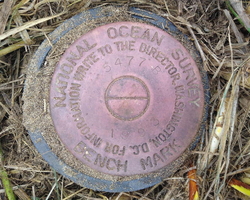
941 5477 B |
| Stamping:
|
5477 B 1993 |
| Stability:
|
Monument will probably hold position well |
| Setting:
|
Stainless steel rod without sleeve (10FT+ or 3.048M+) |
| Mark Condition:
|
G |
| Description:
|
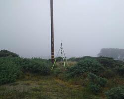
The bench mark is a disk located to the east of Marine View Dr. in Lawson Landing Campground, 75.41m (247.4ft) north of the north face of a small white building, 19.42m (63.7ft) east of a water spigot that is protected by two red bollards, and 1.83 m (6.0 ft) SW of power pole # 4067. |
| Observed:
|
2022-03-15T18:14:00Z |
more obs 2011-11-04
|
| Source:
|
OPUS - page5 2008.25 |
|
|

|
| Close-up View
|
|
| REF_FRAME:
NAD_83(2011) |
EPOCH:
2010.0000 |
SOURCE:
NAVD88 (Computed using GEOID18) |
UNITS:
m |
SET PROFILE
|
DETAILS
|
|
| LAT:
|
38° 14' 0.13873"
|
± 0.004
m |
| LON:
|
-122° 58' 6.40254"
|
±
0.005
m |
| ELL HT:
|
-28.769 |
±
0.007
m |
| X:
|
-2729819.151 |
±
0.008
m |
| Y:
|
-4208625.442 |
±
0.006
m |
| Z:
|
3925806.236 |
±
0.003
m |
| ORTHO HT:
|
3.541 |
±
0.063
m |
|
|
UTM
10 |
SPC
403(CA 3) |
| NORTHING:
|
4231709.100m |
695225.430m |
| EASTING:
|
502761.629m |
1783911.982m |
| CONVERGENCE:
|
0.01952778°
|
-1.51126111°
|
| POINT SCALE:
|
0.99960009 |
0.99996454 |
| COMBINED FACTOR:
|
0.99960460 |
0.99996905 |
|
|
|

|
| Horizon View
|
|
|
|
|