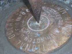
Shared Solution

PID: BBCM84
Designation: 945 0364 A
Stamping: 945 0364 A 2008
Stability: May hold, commonly subject to ground movement
Setting: In rock outcrop or ledge
Description: The bench mark is a disk set flush in a 1 m x 1 m (3 ft x 3 ft) flat rock 177 m ( 581 ft) bearing 074 T from the large shed at the southern end of the pier, 90 m (295 ft) bearing 135 T from primary bench mark 9450364 C 2008, 90 m (295 ft) bearing 126 T from the tan shed NE of the northern end of the pier, and 0.31 m (1.02 ft) above the apparent high water line.
Observed: 2008-10-08T17:29:00Z more obs Original
Source: OPUS - page5 1209.04
Close-up View
REF_FRAME:   NAD_83(2011) EPOCH:   2010.0000 SOURCE:   NAVD88 (Computed using GEOID12B) UNITS:  m  SET PROFILE   DETAILS
LAT: 55° 12' 7.90133" ±  0.005   m
LON: -132° 49' 23.08474" ±   0.003   m
ELL HT: -1.161 ±   0.004   m
X: -2479769.220 ±   0.002  m
Y: -2675744.369 ±   0.003  m
Z: 5214260.879 ±   0.006  m
ORTHO HT: 3.569 ±  0.010   m
UTM  8 SPC  5001(AK 1)
NORTHING: 6119453.510m 375271.351m
EASTING: 638541.679m 872405.026m
CONVERGENCE: 1.78790646° 0.71066736°
POINT SCALE: 0.99983546 0.99997258
COMBINED FACTOR: 0.99983564 0.99997276
CONTRIBUTED BY
corey.allen
National Oceanic and Atmospheric Administration
Horizon View
The numerical values for this position solution have satisfied the quality control criteria of the National Geodetic Survey. The contributor has verified that the information submitted is accurate and complete.