| PID:
|
BBCM26 |
| Designation:
|
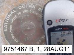
975 1467 B |
| Stamping:
|
1467 B 2011 |
| Stability:
|
Monument will probably hold position well |
| Setting:
|
In rock outcrop or ledge |
| Description:
|
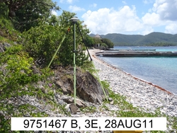
The station is a disk set flush at the base of a bedrock slope above a stone beach on the southern side of Lovango Cay, 49.59m (162.7 ft) W of bench mark 975 1467 A, 49.39m (162.0 ft) W of a 2m (6 ft) tall yellow bollard at west edge of the concrete ramp above a pair of docks, 39.71m (130.3 ft) E of bench mark 975 1467 C, 6.40 m (21.0 ft) N of the water's edge, and 0.25m (0.8 ft) above the stone beach. |
| Observed:
|
2011-08-30T15:20:00Z |
| Source:
|
OPUS - page5 1209.04 |
|
|
|
| Close-up View
|
|
| REF_FRAME:
NAD_83(2011) |
EPOCH:
2010.0000 |
SOURCE:
H = h-N (N = GEOID18 HGT) |
UNITS:
m |
SET PROFILE
|
DETAILS
|
|
| LAT:
|
18° 21' 39.65666"
|
± 0.010
m |
| LON:
|
-64° 48' 13.91589"
|
±
0.012
m |
| ELL HT:
|
-40.804 |
±
0.018
m |
| X:
|
2577895.300 |
±
0.004
m |
| Y:
|
-5479265.870 |
±
0.021
m |
| Z:
|
1996334.889 |
±
0.010
m |
| ORTHO HT:
|
1.420 |
±
0.082
m |
|
|
UTM
20 |
SPC
5200(PRVI) |
| NORTHING:
|
2031072.992m |
259170.907m |
| EASTING:
|
309405.016m |
372211.302m |
| CONVERGENCE:
|
-0.56839594°
|
0.50984123°
|
| POINT SCALE:
|
1.00004911 |
0.99999641 |
| COMBINED FACTOR:
|
1.00005553 |
1.00000282 |
|
|
|
|
| Horizon View
|
|
|
|
|