| PID:
|
BBCL54 |
| Designation:
|
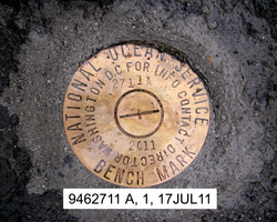
946 2711 A |
| Stamping:
|
2711 A 2011 |
| Stability:
|
Monument will probably hold position well |
| Setting:
|
In rock outcrop or ledge |
| Description:
|
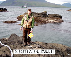
The station is a disk set flush in the second bedrock outcrop on the south end of the sand beach at Surf Bay, 19.37 m (63.5 ft) ESE from the high point at the seaward end of the second rock outcrop, 13.30 m (43.6 ft) slope NW of the high point of the vegetation line on the rock outcrop, 4.70 m (15.4 ft) SSW of the high water line on the beach side of the outcrop, 4.11 m (13.5 ft) NNE of the high water line on the SW side of the outcrop. |
| Observed:
|
2011-07-17T04:31:00Z |
more obs Original
|
| Source:
|
OPUS - page5 1209.04 |
|
|
|
| Close-up View
|
|
| REF_FRAME:
NAD_83(2011) |
EPOCH:
2010.0000 |
SOURCE:
NAVD88 (Computed using GEOID12B) |
UNITS:
m |
SET PROFILE
|
DETAILS
|
|
| LAT:
|
54° 8' 58.46194"
|
± 0.005
m |
| LON:
|
-165° 36' 58.16705"
|
±
0.001
m |
| ELL HT:
|
19.371 |
±
0.005
m |
| X:
|
-3626390.600 |
±
0.004
m |
| Y:
|
-930008.865 |
±
0.002
m |
| Z:
|
5146527.628 |
±
0.005
m |
| ORTHO HT:
|
2.735 |
±
0.010
m |
|
|
UTM
3 |
SPC
5010(AK10) |
| NORTHING:
|
6000338.805m |
399389.412m |
| EASTING:
|
459756.322m |
1676204.909m |
| CONVERGENCE:
|
-0.49943230°
|
8.27511657°
|
| POINT SCALE:
|
0.99961987 |
1.00011248 |
| COMBINED FACTOR:
|
0.99961684 |
1.00010945 |
|
|
|
|
| Horizon View
|
|
|
|
|