| PID:
|
BBCK21 |
| Designation:
|
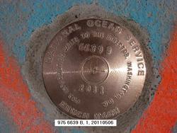
975 6639 B |
| Stamping:
|
6639 B 2011 |
| Stability:
|
Monument will probably hold position well |
| Setting:
|
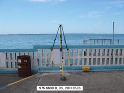
Retaining wall or concrete ledge |
| Description:
|
THE BENCH MARK IS A DISK SET IN THE CONCRETE CAP OF THE SHEETPILE SEAWALL WITH A 1.1 M (3.6 FT) HIGH CONCRETE RAIL, 20.60 M (67.6 FT) SOUTH OF THE SE CORNER OF SEA ANGELS RESTAURANT, 18.37 M (60.3 FT) SOUTH OF THE METAL LIGHT POLE ON THE NORTH SIDE OF THE STREET EAST OF THE RESTAURANT, 15.31 M (50.2 FT) WEST OF A 30 DEGREE BEND IN THE SEAWALL, 13.25 M (43.5 FT) EAST OF THE EAST SIDE OF THE ENTRANCE TO THE DOCK AND 1.02 M (3.3 FT) WEST OF THE EAST END OF THE SIDEWALK. |
| Observed:
|
2011-05-06T13:59:00Z |
more obs Latest
|
| Source:
|
OPUS - page5 1106.16 |
|
|
|
| Close-up View
|
|
| REF_FRAME:
NAD_83(CORS96) |
EPOCH:
2002.0000 |
SOURCE:
No official datum supported (FAQs 19,20). |
UNITS:
m |
SET PROFILE
|
DETAILS
|
|
| LAT:
|
17° 57' 15.88421"
|
± 0.014
m |
| LON:
|
-66° 24' 31.06839"
|
±
0.012
m |
| ELL HT:
|
-37.463 |
±
0.007
m |
| X:
|
2429052.736 |
±
0.011
m |
| Y:
|
-5562165.548 |
±
0.010
m |
| Z:
|
1953573.603 |
±
0.012
m |
| ORTHO HT:
|
2.523 |
±
m |
|
|
UTM
19 |
SPC
5200(PRVI ) |
| NORTHING:
|
1987056.203m |
213401.250m |
| EASTING:
|
774475.925m |
202616.881m |
| CONVERGENCE:
|
0.79931848°
|
0.00772935°
|
| POINT SCALE:
|
1.00053153 |
1.00000572 |
| COMBINED FACTOR:
|
1.00053742 |
1.00001161 |
|
|
|
|
| Horizon View
|
|
|
|
|