| PID:
|
BBCK20 |
| Designation:
|
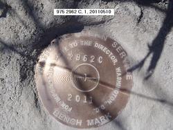
975 2962 C |
| Stamping:
|
2962 C 2011 |
| Stability:
|
Most reliable; expected to hold position well |
| Setting:
|
In rock outcrop or ledge |
| Description:
|
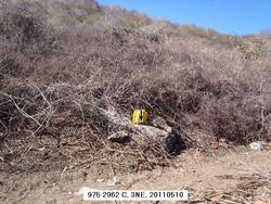
THE BENCH MARK IS SET IN A ROCK OUTCROP AT THE BASE OF A HILL CLOSER TO THE EAST SIDE OF THE ISLAND, 154.2 M (505.9 FT) ENE OF THE SE CORNER OF A WHITE BUILDING SOUTH OF THE RESTAURANT THAT IS EAST OF THE DOCK, 31.90 M (104.7 FT) NE OF A BUSHY TREE IN BETWEEN DIRT TRACTOR TRAILS ON THE NORTH SIDE OF THE GRASS MEADOW, 28.53 M (93.6 FT) NE OF THE BEGINNING OF A TRACTOR TRAIL ON THE NORTH SIDE OF THE GRASS MEADOW AND ABOUT 1 M (3.3 FT) HIGHER THAN THE GROUND. |
| Observed:
|
2011-05-07T20:25:00Z |
more obs Latest
|
| Source:
|
OPUS - page5 1106.16 |
|
|
|
| Close-up View
|
|
| REF_FRAME:
NAD_83(CORS96) |
EPOCH:
2002.0000 |
SOURCE:
No official datum supported (FAQs 19,20). |
UNITS:
m |
SET PROFILE
|
DETAILS
|
|
| LAT:
|
18° 20' 43.91309"
|
± 0.007
m |
| LON:
|
-65° 34' 2.55141"
|
±
0.023
m |
| ELL HT:
|
-38.268 |
±
0.014
m |
| X:
|
2504877.399 |
±
0.022
m |
| Y:
|
-5513624.302 |
±
0.013
m |
| Z:
|
1994709.003 |
±
0.011
m |
| ORTHO HT:
|
3.949 |
±
m |
|
|
UTM
20 |
SPC
5200(PRVI ) |
| NORTHING:
|
2030328.734m |
256907.247m |
| EASTING:
|
228671.862m |
291528.266m |
| CONVERGENCE:
|
-0.80856979°
|
0.27094801°
|
| POINT SCALE:
|
1.00051023 |
0.99999585 |
| COMBINED FACTOR:
|
1.00051625 |
1.00000187 |
|
|
|
|
| Horizon View
|
|
|
|
|