| PID:
|
BBCJ18 |
| Designation:
|
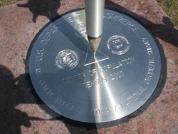
CENTER OF POPULATION CENSUS 2010 |
| Stamping:
|
CENTER OF POPULATION CENSUS 2010 |
| Stability:
|
Monument will probably hold position well |
| Setting:
|
Set in top of concrete monument |
| Description:
|
Located in Plato, MO, in Sec 2, T32N, R12W, 5 mi west along State Hwy 32 from junction with State Hwy 17 at Roby.
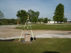
The mark is a commemorative stainless steel disk set into the top of a 20-inch square red granite stone, set to a depth of 4 ft and projecting 24" above ground. It is 55.0 ft S from centerline of State Hwy 32, 60.6 ft SE from NE corner of U.S. Post Office, and 13.0 ft SE from SE corner of a 1994 concrete structure revealing an inscription about town of Plato. |
| Observed:
|
2011-05-07T19:13:00Z |
more obs Original
|
| Source:
|
OPUS - page5 1209.04 |
|
|

|
| Close-up View
|
|
| REF_FRAME:
NAD_83(2011) |
EPOCH:
2010.0000 |
SOURCE:
NAVD88 (Computed using GEOID18) |
UNITS:
m |
SET PROFILE
|
DETAILS
|
|
| LAT:
|
37° 30' 12.08177"
|
± 0.007
m |
| LON:
|
-92° 13' 23.99540"
|
±
0.003
m |
| ELL HT:
|
316.384 |
±
0.011
m |
| X:
|
-196550.729 |
±
0.003
m |
| Y:
|
-5062614.984 |
±
0.010
m |
| Z:
|
3862052.216 |
±
0.010
m |
| ORTHO HT:
|
346.533 |
±
0.060
m |
|
|
UTM
15 |
SPC
2402(MO C) |
| NORTHING:
|
4150996.941m |
185348.461m |
| EASTING:
|
568647.214m |
524461.785m |
| CONVERGENCE:
|
0.47286004°
|
0.16843846°
|
| POINT SCALE:
|
0.99965805 |
0.99994070 |
| COMBINED FACTOR:
|
0.99960842 |
0.99989106 |
|
|
|

|
| Horizon View
|
|
|
|
|