| PID:
|
BBCJ02 |
| Designation:
|
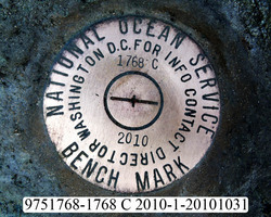
975 1768 C |
| Stamping:
|
1768 C 2010 |
| Stability:
|
Most reliable; expected to hold position well |
| Setting:
|
In rock outcrop or ledge |
| Description:
|
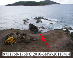
The station is a disk set flush in bedrock on the largest and easternmost of three bedrock points extending north into the water from the end of Ruy Point, 30.17 m (99.0 ft) NE of bench mark 975 1768 D, 19.25 m (63.15 ft) slope distance north of the grass line at the top of the bluff, 15.77 m (51.7 ft) NW of the southernmost of two jointed bedrock pinnacle points at the water line on the east side of Ruy Point, and 15.31 m (50.2 ft) NW of bench mark 975 1768 C. |
| Observed:
|
2011-04-12T21:13:00Z |
more obs Original
|
| Source:
|
OPUS - page5 1209.04 |
|
|
|
| Close-up View
|
|
| REF_FRAME:
NAD_83(2011) |
EPOCH:
2010.0000 |
SOURCE:
H = h-N (N = GEOID18 HGT) |
UNITS:
m |
SET PROFILE
|
DETAILS
|
|
| LAT:
|
18° 22' 17.48581"
|
± 0.006
m |
| LON:
|
-64° 57' 48.38916"
|
±
0.013
m |
| ELL HT:
|
-39.871 |
±
0.022
m |
| X:
|
2562470.165 |
±
0.014
m |
| Y:
|
-5486093.133 |
±
0.021
m |
| Z:
|
1997439.015 |
±
0.012
m |
| ORTHO HT:
|
2.407 |
±
0.066
m |
|
|
UTM
20 |
SPC
5200(PRVI) |
| NORTHING:
|
2032410.889m |
260191.228m |
| EASTING:
|
292551.807m |
355337.471m |
| CONVERGENCE:
|
-0.61905463°
|
0.45991181°
|
| POINT SCALE:
|
1.00013205 |
0.99999683 |
| COMBINED FACTOR:
|
1.00013832 |
1.00000310 |
|
|
|
|
| Horizon View
|
|
|
|
|