| PID:
|
BBCJ01 |
| Designation:
|
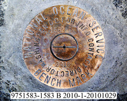
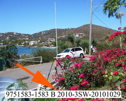
975 1583 B |
| Stamping:
|
1583 B 2010 |
| Stability:
|
|
| Setting:
|
Unspecified rock or boulder |
| Description:
|
The station is a disk set flush in the top of a large partially buried rock on the north side of the gravel road to the Coral World dock, 20.83 m (68.33 ft) east of a lighted power pole on the south side of the intersection of the driveway to the dock and the road, 15.04 m (49.34 ft) south of the SE corner of the administration building, 11.37 m (37.30 ft) SSE of the centerline of the road to the eastern most parking lot, and 4.89 m (16.04 ft) north of the centerline of the driveway to the dock. |
| Observed:
|
2011-04-11T15:00:00Z |
more obs Latest
|
| Source:
|
OPUS - page5 1009.28 |
|
|
|
| Close-up View
|
|
| REF_FRAME:
NAD_83(CORS96) |
EPOCH:
2002.0000 |
SOURCE:
No official datum supported (FAQs 19,20). |
UNITS:
m |
SET PROFILE
|
DETAILS
|
|
| LAT:
|
18° 20' 57.21542"
|
± 0.015
m |
| LON:
|
-64° 51' 50.67943"
|
±
0.021
m |
| ELL HT:
|
-36.127 |
±
0.071
m |
| X:
|
2572312.149 |
±
0.034
m |
| Y:
|
-5482347.972 |
±
0.064
m |
| Z:
|
1995097.873 |
±
0.037
m |
| ORTHO HT:
|
6.513 |
±
m |
|
|
UTM
20 |
SPC
5200(PRVI ) |
| NORTHING:
|
2029832.258m |
257810.496m |
| EASTING:
|
303027.898m |
365859.091m |
| CONVERGENCE:
|
-0.58701665°
|
0.49100158°
|
| POINT SCALE:
|
1.00007967 |
0.99999598 |
| COMBINED FACTOR:
|
1.00008535 |
1.00000166 |
|
|
|
|
| Horizon View
|
|
|
|
|