| PID:
|
BBCH99 |
| Designation:
|
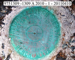
975 1309 A |
| Stamping:
|
1309 A 2010 |
| Stability:
|
Most reliable; expected to hold position well |
| Setting:
|
In rock outcrop or ledge |
| Description:
|
The station is set flush in bedrock on the east side of Leinster Point near the north end of a sand and gravel beach, 19.05 m (62.5 ft) south of bench mark 975 1309 B, 7.45 m (24.4 ft) north of the north end of the beach, 4.54 m (14.9 ft) east of a prominent triangular shattered bedrock cliff face extending out of the grass and trees above the north end of the beach, and 0.99 m (3.25 ft) SE of vegetation line. |
| Observed:
|
2011-04-09T16:00:00Z |
more obs Latest
|
| Source:
|
OPUS - page5 1009.28 |
|
|
|
| Close-up View
|
|
| REF_FRAME:
NAD_83(CORS96) |
EPOCH:
2002.0000 |
SOURCE:
No official datum supported (FAQs 19,20). |
UNITS:
m |
SET PROFILE
|
DETAILS
|
|
| LAT:
|
18° 22' 3.41138"
|
± 0.008
m |
| LON:
|
-64° 43' 13.02384"
|
±
0.021
m |
| ELL HT:
|
-41.084 |
±
0.020
m |
| X:
|
2585787.144 |
±
0.028
m |
| Y:
|
-5475291.189 |
±
0.016
m |
| Z:
|
1997027.957 |
±
0.002
m |
| ORTHO HT:
|
1.623 |
±
m |
|
|
UTM
20 |
SPC
5200(PRVI ) |
| NORTHING:
|
2031717.720m |
259981.847m |
| EASTING:
|
318245.235m |
381037.541m |
| CONVERGENCE:
|
-0.54223281°
|
0.53599278°
|
| POINT SCALE:
|
1.00000841 |
0.99999667 |
| COMBINED FACTOR:
|
1.00001487 |
1.00000313 |
|
|
|
|
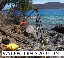
| Horizon View
|
|
|
|
|