| PID:
|
BBCD10 |
| Designation:
|
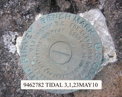
946 2782 TIDAL 3 |
| Stamping:
|
NO 3 |
| Stability:
|
Most reliable; expected to hold position well |
| Setting:
|
In rock outcrop or ledge |
| Description:
|
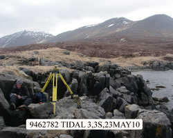
The mark is near the west end of a small rock peninsula at the head of Tigalda Bay, 21.05 m (69.1 ft) west of bench mark 946 2782 TIDAL 4, 12.28 m (40.3 ft) SW of bench mark 946 2782 TIDAL 2, 10.55 m (34.6 ft) west of the boulder that is the prominent high point on this peninsula, 7.37 m (24.2 ft) south of bench mark 946 2782 TIDAL 1, 2.95 m (7.4 ft) east of the seaward edge of rock, and 1.98 m (6.5 ft) north of top edge of 10 m (33 ft) high rock wall. |
| Observed:
|
2010-05-22T04:30:00Z |
more obs Latest
|
| Source:
|
OPUS - page5 1009.28 |
|
|
|
| Close-up View
|
|
| REF_FRAME:
NAD_83(CORS96) |
EPOCH:
2003.0000 |
SOURCE:
NAVD88 (Computed using GEOID09) |
UNITS:
m |
SET PROFILE
|
DETAILS
|
|
| LAT:
|
54° 7' 5.16501"
|
± 0.006
m |
| LON:
|
-164° 58' 34.88647"
|
±
0.014
m |
| ELL HT:
|
23.021 |
±
0.022
m |
| X:
|
-3618523.499 |
±
0.019
m |
| Y:
|
-971180.985 |
±
0.010
m |
| Z:
|
5144478.193 |
±
0.016
m |
| ORTHO HT:
|
6.409 |
±
0.038
m |
|
|
UTM
3 |
SPC
5010(AK10 ) |
| NORTHING:
|
5996662.068m |
402128.653m |
| EASTING:
|
501545.375m |
1718086.891m |
| CONVERGENCE:
|
0.01915591°
|
8.78498764°
|
| POINT SCALE:
|
0.99960003 |
1.00009988 |
| COMBINED FACTOR:
|
0.99959643 |
1.00009628 |
|
|
|
|
| Horizon View
|
|
|
|
|